
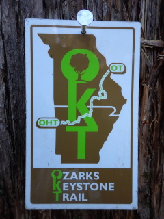
The Ozarks Keystone Trail (OKT), when completed, will run about 85 miles along Norfork Lake between Dawt MO (just north of US-160) and the Norfork Lake dam near Norfork AR. It is the keystone that will connect Missouri’s Ozark Trail (OT) to Arkansas’ Ozark Highlands Trail (OHT) to form the Trans-Ozark Trail (TOT). OT + OKT + OHT = TOT.
General Information
The route is on US Corps of Engineers (COE) property and follows the lake shoreline in a general way. My information for COE-managed areas is currently rather spotty.
COE expects all camping to be done in their designated campgrounds – no backcountry-style camping along the trail. COE campgrounds are typically closed November-March (some longer) which would mean no potable water and no toilet facilities. The good news is that you can still camp there without paying the normal fees. The long-term plan is to build some official backcountry sites.
Check lake levels to see if parts of the trail might be underwater.
Donate to the Ozarks Keystone Trail Endowment.
The OKT from the Norfork Lake dam north to the MO-AR state line will begin sporting mile markers for the Ozark Highlands Trail and the location of these markers are shown on my maps and those from Underwood Geographics. Mile 0 is at Lake Fort Smith, the Norfork Lake dam is mile 263 and the state line is mile 324.
Maps
Here’s some general info about my maps. Every time I update a map the file will have a different name so if you want to bookmark or share it, link to this page – not the file.
This one page overview of the OKT area can be useful to see the relationship of the trail heads to each other and to various roads, and what trail is finished. It is intended to be a 24″x36″ poster (1:66000 scale) so isn’t generally practical for printing but you can certainly view it on a screen. It covers the area from the Ozark Trail’s Collins Ridge to the Ozark Highlands Trail’s Matney Knob trail heads.
The more-detailed map set is a 6-page PDF that will be about 1:24000 scale on 11×17″ paper. The pages are numbered from south to north to match the “flow” of the other maps in the Trans-Ozark set but it feels weird so I might change that.
Something new is an 11-page PDF that is sized for 8.5″x11″ paper. The scale is still 1:24000 so you don’t see as much of the surrounding area versus the larger page. This set has a separate cover page with the legend, all the trail access locations, and an index map showing the coverage for each page. I may give all my multipage maps this same treatment.
v8, Apr 24 2025: The location of OHT mile markers (installation by OHTA to begin soon?) are now shown.
v7, Dec 28 2024: Corrected the trail path between Red Bank & Seward Point trail heads. Show trail parking outside the gate at Lagoon Road (between Panther Creek and Robinson Point). Some of the segment mileages north of Bidwell Point have been changed.
v6, Nov 29 2024: Minor corrections to some roads and the OKT track. The suggested road walk between Matney Knob and the Norfork Dam is highlighted.
v5, Sep 8 2024: The trail between Bean Bluff and the state line is now shown as finished. A newer route is used for the unbuilt trail between CR 1028 and the Panther Creek bridge. Added a trail parking area at Niles Landing Access.
Newer (2025+) editions of the Underwood Geographics Ozark Highlands Trail, North map show this trail, and the area all the way north to Dawt Mill.
Trail and Trail Head Information
All coordinates below are WGS84. Mileages are from a GPS track and will be revised as trail is constructed & walked. Trail head and segment information is listed north to south, divided into 4 sections. Except for the last southern section, construction and maintenance is done with machinery and generally results in a 6-foot tread width. One consequence is that the trail is routed where it is most favorable for the machine – going up and down hills instead of contouring around them. Blazing is, or soon will be, primarily blue paint on the trees. Some areas also have tags like in the photo above about 1/4-mile apart.
- Dawt Mill, MO is intended to be the northern end of the OKT and the point of connection to the OT. It’s on County Rd 318 about 0.7 miles west of MO-PP. About 3 miles of trail will be needed to fill this gap.
- Tecumseh Access: 36.5880°N, 92.2895°W. North side of US-160, west side of North Fork River. Parking only, the primitive campground, potable water and vault toilets are no longer available.
- About 6.25 miles of incomplete trail. Includes a 1.4 mile road-walk on CR 551B and a 0.55 mile road-walk through Udall Park.
- Udall Park: about 36.5442°N, 92.2873°W. Primitive campground, potable water, vault toilet.
- About 8 miles of incomplete trail to the MO/AR state line, then about 3.3 miles finished. This stretch includes a crossing of Barren Creek, which will likely require wading. Check water levels too as this area could even be under deep water with no easy detour.
- Barren Creek (mile 320.7): COE gate north of CR44 at 36.4848°N, 92.2416°W. North edge of the Niles Landing Access area.
- About 0.6 miles of finished trail to a spur to the Niles Landing Access trail parking (mile 320.1).
- About 5.1 miles of finished trail to Red Bank Access (mile 315.0). In my opinion, the Bean Bluff area is one of the nicest sections of the whole OKT.
The trail from Red Bank through Robinson Point is also known as David’s Trail so you will see that name on trail signs, monuments, etc.
- Red Bank Access (mile 315.0): 36.4497°N, 92.2668°W, no camping, no facilities, ample parking in boat launch area.
- 1.5 miles of finished trail.
- Seward Point (mile 313.5): 36.4357°N, 92.2596°W, parking for 5-6 cars at the north end of the Wildlife Management Area (WMA).
- 8 miles of finished trail, mostly in the WMA. Access to the Piney Point and Mallard Ridge spur trails. The WMA has a very wildernessy vibe. This section is actually about 1 mile longer than the mile numbers suggest due to a misnumberment (#308 to #309 is 2 miles).
- Bidwell Point Park (mile 306.7): 36.3901°N, 92.2468°W. The trail passes near the entrance but does not go through the Park. Campground, toilet, potable water, showers in-season. A day-use fee may be required to park there.
- 0.9 miles, mostly on the AR-101 bridge. There is a 3 foot shoulder on each side of the bridge so walk on the side that has you facing traffic. Beware the blast of wind from large trucks. At the north end there is a large David’s Trail monument at the edge of the woods next to the trail. At the south end there are small brown OKT signs attached to a couple trees on the east side to mark the trail.
- Panther Bay Park Day Use (mile 305.8): 36.3783°W, 92.2494°W, ample parking (a day-use fee may be required), campground, potable water, showers in-season. There is bathroom near the trail head that is open all year.
- 5.7 miles of finished trail. Goes under the US-62/412 bridge.
- Robinson Point Park (mile 300.1): 36.3571°N, 92.2467°W, ample (free) parking, campground, toilets, showers, potable water in-season.
- 1.4 miles of finished trail to the lake overlook.
The longer path through the Robinson Point area adds about 0.5 miles. Taking the shortcut to the lake overlook subtracts about 0.15 miles. Some of the trail through the Robinson Point area is also known as the Robinson Point Trail.
- 5.6 miles of finished trail.
- CR 396 bridge (Panther Creek) (mile 293.2): 36.3696°N, 92.2849°W, parking for 2-3 cars on shoulder at east end of bridge. No facilities.
- Gap of about 18 miles. As of Jan ’26 a crew of OKTE and OHTA volunteers has flagged a route and begun clearing the corridor. This section will be single-track and hand-built.
The southern-most section is the 12.25 miles originally called the Norfork Lake Trail. It was built in the 90’s in a traditional hand-dug manner – it tends to follow the contours around hills and in/out of drainages. There’s not a whole lot of elevation change.
- CR 1028 (Fish & Fiddle Rd) (mile 275.2): 36.3097°N, 92.2715°W, no facilities, room for 1 car after descending a hill on a very bad road. Better to park at the top of the hill just before the road begins descending (room for 3 or 4 cars), then walk 1/8-mile down to the trail head.
- 2.4 miles.
- Tracy Access (mile 272.8): ample room in day use parking lot at 36.2992°N, 92.2686°W. Walk back up the hill .2 miles to the trail crossing.
- 2.7 miles.
- Georges Cove Access (mile 270.1): 36.2928°N, 92.2553°W, can accomodate 4-5 cars, no facilities. There are facilities in the Recreation Area farther east along the road.
- 2.3 miles.
- Sycamore Highlands (mile 267.8): 36.2818°N, 92.2607°W, 3-4 parking spaces, no facilities, at edge of Sycamore Highlands subdivision, 1/8-mile spur to trail. The COE calls this the Devil’s Backbone trail head.
- 2.3 miles.
- Shoal Creek (mile 265.5): 36.2738°N, 92.2637°W, no facilities, room for 3 cars, rutted road at east edge of Briarcliff, walk 415′ downhill to trail crossing. Update: The Corps of Engineers has gated the road. You can park at the gate and walk even farther down the road.
- 2.5 miles.
- Norfork Dam/Quarry Park Day Use Area (mile 263.0): 36.2565°N, 92.2405°W. East side of AR-177, just north of the dam. Ample free parking. The trail begins to the NE across the marina road, through a wooden “gate”.
If you are continuing on to the Ozark Highlands Trail, there is a 9.5-mile road-walk that will get you to Matney Knob (mile 253) 36.2142°N 92.3082°W. Head SE across the dam on AR-177 about 2 miles to Norfork River Road. Turn right (WSW) and go about 4.7 miles to AR-5 in Norfork. Turn right (N) for about 0.5 miles and then left (NW) onto AR-341 for about 0.9 miles. Turn left (SW) to stay on AR-341 and go the final 1.4 miles to the Matney Knob trail head on the right. There are a variety of food and lodging options in Norfork.
This route is safer for pedestrians even if 3 miles longer than taking AR-177 W past the Quarry Park Campground and AR-5 SW, etc.
Last review/update: Oct 31 2025


Thanks for all your hard work Mike. How close are they to completing this route to the OT?
Not very, I think. I believe the Ozark Trail Association is doing all the construction north of the state line. I know they have had at least one Mega Event. I’ve got a contact there so will start doing more research on the segment to Dawt. Between Dawt & Collins Ridge might always be a road walk because of the property issues.