
This was the first trail I hiked in Arkansas during visits almost 5 and 6 years ago and reading those posts again sure brings back some memories. My intention this time was a 2-night backpacking trip from Gunner Pool east to Allison and back, then west as far as I could go and back in the remaining time. When I got to Gunner Pool I found a bulldozer and USFS chainsaw crew cleaning up damage from a big wind storm a few nights earlier, and the trail closed in both directions. I headed for the west end – the Cripple Turkey trail head – to see if it was open, and it was. On the way up AR-314 I could see smoke from yet another wildfire in the Leatherwood Wilderness.
The trail east of the Cripple Turkey trail head was in pretty good shape. I kicked a lot of small stuff off the trail and had a pruning saw to cut the few medium-size branches I encountered. I reported the location of the big stuff to the forest service but there was nothing here that presented any real obstacle.
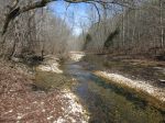
The trail was much as I remembered. Between Cripple Turkey and the Barkshed Creek crossing it pretty much follows Cole Fork Creek but at a distance and a relatively high elevation. It’s a nice hike, but nothing really special. It’s shortly after the Barkshed Creek crossing that Cole Fork Creek empties into North Sylamore Creek and the trail starts getting more interesting, with some pretty dramatic bluff lines and steep hollows with waterfalls. From here to Allison, in fact, the area is like a smaller version of the Buffalo River valley.
There is a ridge a short distance above the trail about a mile upstream of the Barkshed Rec Area and the map suggested I would probably find a place to put a tent up there but as luck would have it, the area had burned very recently and was therefore a bit inhospitable. I had to push on to the Barkshed Rec Area and stay in the campground there, between the many toppled trees. I suspected that was a taste of the wreckage further downstream and decided that I would cut the trip short and turn around there but I won’t wait another 5 or 6 years to get back and see the rest of the trail again.


-

- Trees down in the Barkshed campground
-

- Trees down in the Barkshed campground


I appreciate your detailed hiking write ups! – I am looking to do my first real backpacking trip on the Sylamore late this Sept, and leaning on the fact folks call these “day hikes” to ensure I don’t overdo things.
I hear Blanchard is still closed, so current idea is to have outfitter take me to Cripple Turkey, then hike to Barkshed to overnight, then on to Gunner Pool to meet my family.
In the event I’m overplanning and cover too much ground, I could push through Barkshed and find a dispersed spot for my hammock closer to Gunner Pool, then make the second day a short hike to meet family, maybe explore the Sylamore further down toward Blanchard (I believe that section was opened by volunteers this Spring?).
Are there any resources outside your awesome blog you could point me to, to get better context on what to expect trying an overnight on the Sylamore Trail?
Sorry for the delay, I’ve been out west. OuachitaMaps.com has some info on that trail. It may be kinda old but could still be useful. Overall, it sounds like a doable plan. The trail is open downstream to Blanchard Springs, and the cave tours are still happening so that part is open, at least, and perhaps you could get picked-up there.