
My 5th annual trip to the Wind River Range! This time we started in the Elkhart Park area, near Pinedale, at the Pole Creek trail head. The target area is almost entirely within the Bridger Wilderness of the Bridger-Teton National Forest.
The route is described in Nancy Pallister’s “Beyond Trails…“ (trip #30 in 2nd ed) and we did it over about 6.5 days. Someone better acclimated to the altitude could certainly do it quicker. The basics are: the Pole Creek trail past Photographer’s Point, Seneca Lake trail past Barbara, Hobbs, and Seneca Lakes, the Indian Pass Trail past Island Lake with a side trip into Titcomb Basin, then over the pass into Indian Basin. Bushwhack south and over the Island/Wall pass to Wall and Cook Lakes. Cook Lake & Highline trails to Pole Creek Lake, and then take the Pole Creek trail back. We added a detour through the Sweeney Lakes to Miller Lake for our final camp. The Wind River maps from Beartooth Publishing are highly recommended. The Great Outdoor Shop in Pinedale has them if you can’t find them elsewhere.
We had some pretty good weather with highs in the mid-70s to 80 and lows mostly around 40. The skies were clear the first 4 days with a good shower on night 5, some sprinkles during afternoon 6, and more sprinkles on night 6.
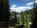
Day 1: We are passed by a lot of people as we hike-in on the Pole Creek trail, which was surprising for a Sunday. It might have been evenly split between day-hikers headed to Photographer’s Point and backpackers. We stopped for lunch at Photographer’s Point, with a great view of Fremont Peak in the distance. It seemed so far, yet we’d be having lunch at its foot in 2 more days. We turned on the Seneca Lake trail to Hobbs Lake. We intended to bushwhack up the slope to Sapphire Lake to camp but found a nice area closer to Hobbs. We were all pretty tired, as we usually are on the first day.
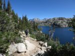
Day 2: We continued N/NE on the Seneca Lake trail past Seneca Lake and Little Seneca Lake, then on the Indian Pass trail toward Island Lake & Titcomb Basin. We intended to camp in the Indian Basin area but that proved far too ambitious for our still-unacclimated bodies and we had to stop at Island Lake. This is a very popular destination for some reason, and was rather crowded and showing signs of overuse. I recommend avoiding camping here.
Day 3: We continued north on the Indian Pass trail and made a side-trip into Titcomb Basin, having lunch on a rocky knob between the two upper lakes, near the foot of Fremont Peak. Afterward, we headed up toward the pass into Indian Basin and then descended to Lake 10813 for the night.
Day 4: I finally feel acclimated to the altitude. We bushwhacked down the outlet of Lake 10813, turned south along Lake 10794 and past a couple smaller lakes before turning east and heading over the Island-Wall Pass. We then descended a bit into a large meadow – perhaps the hanging valley Nancy Pallister described. I think the thing to do here is to bear left and kinda follow the creek down, skirting the edge of the willows. We went right and ended up on a route that was probably much more difficult. We camped near an outcropping at the upper end of Wall Lake.
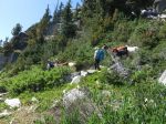
Day 5: We made our way south along the east side of Wall Lake until coming to a large buttress. Nancy Pallister describes this point as the crux and says pack goats and small children have made it across the rather steep granite slab. After about a hour of reconnaissance we saw no good path – we simply couldn’t see around the buttress to figure out where to go – so we climbed up and around the back side. Shortly afterward we ran into a couple that had the same problem, and same solution, on a previous trip. We continued south along Wall Lake about 1/2 mile before veering a bit east down a drainage leading toward the larger of the Cook Lakes, and the Cook Lake trail. We followed the Cook Lake trail southwest around the lakes and along Pole Creek, passing junctions with the Fremont and Highline trails before finding a place to stop for the night.
Day 6: We continued southwest along Pole Creek to Pole Creek Lakes where we turned northwest onto the Pole Creek trail. There’s a nice waterfall where Pole Creek hits the lake. There was a bit of a climb heading away from Pole Creek Lake before the trail levels off and passes many small lakes and makes a scenic descent to Eklund Lake. A bit later we turned south toward the Sweeney lakes, passing Upper Sweeney and along the north edge of Middle Sweeney as we turned west toward Miller Lake and our final camp.
Day 7: Some maps showed the Sweeney Lakes trail heading roughly southwest from Miller Lake and intersecting another trail going west-southwest to the Pole Creek trail and we decided to try that route as a bit of a shortcut. We found signage for that first trail and had no trouble following it but the second trail – what my GPS map calls the Miller-Sweeney Cutoff – does not exist. Much of the route is blazed but there is no trail tread. The blazes lead us through a couple wetland areas, a boulder field, and much downfall. It’s a blazed bushwhack that added a bit of exertion to what we expected to be a pretty leisurely hike out. [Sep 13 ’19 update: it’s likely that this “trail” is actually one of several cross-country ski routes in the area.] It’s now Saturday morning of Labor Day weekend and we pass so very many people hiking in on the Pole Creek trail. Somehow the Winds manages to swallow them all.
We proceeded with what has become our post-trip custom of stuffing ourselves with pizza at Old Stones Smokehouse Country Pizza in Pinedale before beginning the long drive home and thinking about next year.
-
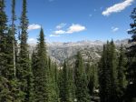
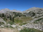
- Fremont Peak and friends, from Photographer’s Point
-
- Barbara Lake
-
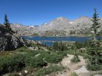
- Fremont Peak, over Seneca Lake
-
- Part of a llama train
-
- Fremont Peak, near junction of Indian Pass and Highline trails
-
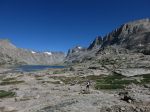
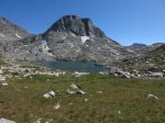
- Fremont Peak and Island Lake
-
- Lake 10467, near “entrance” of Titcomb Basin
-
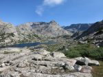
- Titcomb Basin
-
- Titcomb Basin, upper lake
-
- Titcomb Basin, lunch break at foot of Fremont Peak
-
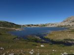
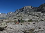
- Indian Basin, upper lakes
-
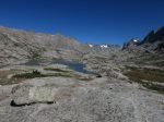
- Indian Basin, Lake 10813
-
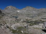
- Indian Basin, Lake 10813 with Elephant Head Peak
-

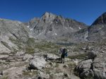
- Heading up Island/Wall Pass, looking back at unnamed lake with Island Lake in distance
-
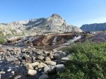
- Pole Creek, cascading into Wall Lake
-
- Wall Lake, upper end
-

- Wall Lake, lower end
-
- A first glimpse of Cook Lakes
-
- One of the inlets for Cook Lake 10143

-
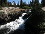
- Pole Creek cascades into Pole Creek Lake
-
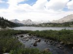
- Two Top Lakes, with rain threatening
-
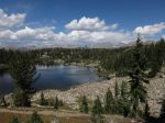
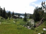
- Eklund Lake, with Fremont Peak growing more distant


I love reading about your adventures and hikes. Most of all I really enjoy your slide shows. You are great at writing articles and better photographer. Keep them coming.
Enjoyed reading the TR. Not certain exactly what dates you were there, but the Pole Ck trail is certainly crowded, by most definitions. I’ve done that crux at Wall a few times. Not easy and cairns are scarce and undependable. Just staying high is the key. I was just looking at the Miller/Sweeney cutoff, which is how I found this page. I believe it’s a horse trail. I’ve been considering it as an alternative to the Pole Creek highway. It may be longer though. Found this description:
https://dreampackerwytrails.blogspot.com/2018/08/fortification-mountain.html