
This was my second time doing the 27-mile Eagle Rock Loop and was accompanied by RC (who was also with me 6 years ago) and first-timer TC. I was surprised at how little of this great scenery I remembered, and think I need to make a point of doing this hike every 2 or 3 years.
We originally intended to begin the trip at the Upper Little Missouri trail head Saturday afternoon as a 3-nighter going “clockwise”, hiking in only a couple miles and setting up camp before dark. The weather forecast was for rain in the late afternoon and evening though, so we instead spent the night in a shelter at the nearby Bard Springs Recreation Area. The West Blaylock Creek trail head is just a few miles east of there and we figured that if we started there instead and still went clockwise it would give water levels at the last couple crossings of the Little Missouri River an extra day to drop after the rain.
As it turned out, the water level on the Langley gauge was about 4′ and all our crossings of the Little Missouri River plus Long, Blaylock, and Crooked creeks required wading. A couple times the water was just over knee level.
-
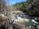
- Little Missouri River Falls

-

- Little Missouri River crossing north of Winding Stair area
-
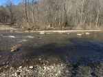
- Little Missouri River crossing at mouth of Viles Branch


I’m hoping to get down there in the next 30 days across a 3 day weekend. I’ll need to get one of my sons to join me, or a volunteer. My wife won’t let me go solo anymore. My last outing involved a helicopter retrieval due to a cardiac issue.
Yikes! Maybe you should just hike the Little Missouri Trail instead of the whole loop? Another idea is to spread it over 5 days to allow extra time for the Athens-Big Fork part.