
I hiked the OHT from Dockery’s Gap to the east side of Lake Fort Smith today (map 1). The starting temperature was 25F and there was still a couple inches of snow on the ground so it definitely felt like winter.
Mine were the first human footprints on the trail, though for the first mile or so I was following what might have been coyote prints. They didn’t deviate from the trail – not even on a series of switchbacks – until we got to the first creek .75 miles in. Turkey tracks, on the other hand, were going everywhere. The only wildlife I actually saw were a couple squirrels and some birds.
There wasn’t anything really note-worthy along this part of the trail but some nearby features could make a return trip worthwhile. There are apparently a couple 50′ waterfalls up one side drainage that might be interesting after a big rain. There is also a very narrow ridge that I want to explore further – it rises steeply about 400′ above the nearby creeks . Many times a feature like this gets named Devil’s Backbone.
Back in the summer I hiked the 5+ miles of trail further west (going around the lake) so I’ve now hiked all of section 1.

-
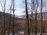
- Lake Fort Smith, from the east side above Jack Creek
-

- Jack Creek, where the OHT crosses


Is there a good place to camp around Dockery’s Gap? This will be my first overnight hike so I was going to camp between Lake Fort Smith and White Rock Mountain. What do you suggest?
As you approach Dockery Gap from the west the terrain is fairly level so there are probably some good sites. Once you cross FR1007 you head down a slope so you probably wouldn’t find a good site until you get down to the Hurricane Creek area.