
Weather, water levels, and schedule conflicts have deterred two previous attempts but the stars aligned this year and I (with a friend) have now done the Eagle Rock Loop – a 27 mile loop consisting of parts of the Little Missouri, Viles Branch, and Athens-Big Fork trails. Rugged Ouachita topography, scenic vistas, geological wonders, and water – lots of it; 9 crossings of the Little Missouri River, 12 crossings of Viles Branch, and more smaller streams than we could count. There is even a hot spring (okay, it’s merely warm).
It’s considered by many to be the most challenging hike in Arkansas and I can now agree. The only hikes I’ve done that were tougher than the Athens-Big Fork section of this loop were in the Colorado Rockies.
This was a 3-night trip, beginning at the Little Missouri trail head and going clockwise – saving the mountain climbs for the last when our packs would be lightest. The water level at the Langley gauge for the Little Missouri River when we started was about 3.3 feet. We managed dry crossings everywhere except the mouth of Long Creek and the last two of the Little Missouri. The deepest water – about knee-deep – was the last crossing.
We had morning temperatures of 16, 26, and 50!, though on this last day, it dropped from 50 to 25 in the 3.5 hours it took us to pack-up and hike-out. It also rained most of this last night though it fortunately stopped about the time we started packing.
-

- The Little Missouri Falls

-

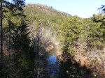
- Near the mouth of Crooked Creek
-
- Crooked Creek flowing from the bottom right into the Little Missouri
-

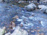
- The “hot” spring. The water was definitely warmer than normal so there must be some kind of geothermal stuff going on there.

-
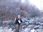
- Step, step, step… Keep your balance and your boots stay dry. If the water level were only a few inches higher many of our dry crossings would have been wet.
-

- Working our way along the base of the bluff across from the Albert Pike area
-

- From atop the bluff across from the Albert Pike area

-
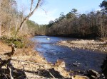
- Our first wet crossing of the Little Missouri
-

- Part of the Winding Stair area
-
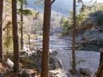
- Looking downstream into more of the Winding Stair area.
-

- More of the Winding Stair area, looking upstream at where the previous picture was taken
-

- Our second and last wet crossing of the Little Missouri, above the mouth of Viles Branch
-

- Part of the view from Eagle Rock Vista
-

- A typical Ouachita hilltop: rocky with stunted oaks
A post-trip dinner at the Branding Iron BBQ & Steak House in Mena provided a very nice change from freeze-dried meals. This was a heck of a satisfying trip and a great way to start 2014.


Michael,
Thanks for the overview. I am planning to take my 3 sons on this trek in the fall and hoped to be able to locate the “hot” spring. I knew there was one somewhere but still don’t know where. I understand it’s off the beaten path but not sure which one. Can you share with me the cords or general location as this is something I would like to see as well. Thanks.
Sorry for the delay! The spring is not far off the trail at about 34.4067, -93.908.