
My seventh trip into the Wind River Range, this one a 5-nighter accompanied by CC, RC, CE, & EE, covered some of the same ground in Bomber Basin as the 2018 trip with RC & CC. We started at the Trail Lake trail head near Dubois WY. At 7600′ elevation it’s one of the lowest trail heads so we’re in for a big climb right from the start. The initial plan was to head south on the Torrey Creek trail to the Glacier Trail junction, then up the G. T. and further south through the pass to the Dinwoody Lakes area. After that, things were fluid.
As usual, helpful resources for the trip included Nancy Pallister’s book, Ben Adkinson’s book, and the map from Beartooth Publishing.
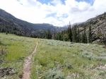
Day 1: We headed south, parallel to East Torrey Creek, and gained about 1000′ over 3.1 miles to the junction with the Glacier Trail. Then it was up 29 switchbacks, gaining 1400′ in about 1.5 miles before staggering out onto the grassy slopes of Arrow Mountain. It began raining as we travered the 1/2-mile to the cluster of trees near the creek crossing at about 10000′. There were said to be some camp sites among the trees and we did eventually find acceptable places for our tents. We found a couple fire rings among the trees but the surrounding areas were flooded. The rain stopped and the clouds parted about dinner time. Overall we hiked about 6 miles and gained 2400′ elevation on our first day. That’s a lot of work for people that live at less than 1000′ elevation so we were all in bed early and slept pretty well.


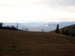
Day 2: We crossed the creek and continued south along Arrow Mountain. We didn’t get far before getting hit with high winds, rain, and graupel. It quit before we got to Glacier Trail Pass (10895′) but we heard stories from people headed north about getting a lot of snow the previous day and we could see it on the mountains ahead as we got to the pass. From the pass, we descended a bit to cross Burro Flat, which was rather wet, often with several inches of water standing on the trail. Nobody escaped with dry socks. We then descended through an old burned area, catching a glimpse of Upper Phillips Lake. Just after crossing the outlet of Phillips Lake we followed a well-worn social trail to Upper Phillips Lake (10230′) and set-up camp at the south end. We were all glad that the most serious threats of rain were behind us. We had a fire ring in our camp site and RC, against all odds, managed to get a fire going though it didn’t last long due to the damp materials on hand.


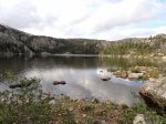
Day 3: We bushwhacked up a boulder-strewn gully to Golden Lake (10560′). Our original plan was that on day 4 we would bushwhack north from Golden Lake out to Goat Flat then WSW across Goat Flat to descend NW through a gully to Bomber Lake – a route described by Nancy Pallister. CC, CE, and I climbed the ridge north of Golden Lake to get a preview of that route. The 1 mile over to Goat Flat looked pretty challenging and when combined with the unknowns of the descent to Bomber Lake we decided we weren’t going that way.
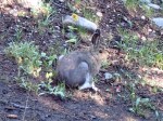
We continued south, boulder-hopping along the shore of Golden Lake to the ouflow of the next-higher lake. The flow was down some enormous granite slabs where we found a porcupine corpse. I’ve still never seen a live one. Rather than return the way we came, we bushwhacked SE down the next drainage south of Phillips Creek, toward Double Lake, but then turned NE back to Upper Phillips Lake when the terrain leveled-off. We actually ended-up on a social trail that Nancy hinted might be there, and followed it all the way back to our camp.


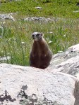
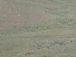
Day 4: With the Goat Flat to Bomber Basin route scratched, we decided to hike back across Burro Flat, through the pass, and back to that cluster of trees where we spent the first night. We looked for Williamson Corrals (a feature on USGS topo maps) but didn’t see anything that looked like a corral, or even remnants. We did find a couple large camp sites in that vicinity. While we were looking around there we saw 6 Big Horn Sheep – 3 adults and 3 juveniles – headed south across Arrow Mountain, the first we’d ever seen in the wild. They were pretty close to the limit of my camera’s optics.
We stopped for lunch, then continued north on the Glacier Trail back down the switchbacks to the junction with the Torrey Creek trail and camped at the north end of the big meadow.


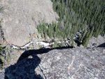
Day 5: We day-hiked south into Bomber Basin. I think the official trail ends at the base of Bomber Falls but we continued on the (sometimes very steep) social trail up to a ridge where we hoped to get a better view of the falls. We didn’t get a better view of the falls but did have a great view looking back down the basin and of the plane wreckage for which the basin is named. During dinner that evening along East Torry Creek we had 2 Martens come by to check us out and perhaps scold us for being in their way. I didn’t have my camera.


Day 6: We had a rather uneventful hike out then went back to Dubois for brunch at the Cowboy Cafe. CC, CE, and EE headed for home. RC & I headed to Sinks Canyon State Park near Lander to spend the night and prepare for our next trip.


The weather was good but not perfect. Highs were generally in upper 50’s/lower 60’s I think, with lows in upper 30’s/lower 40’s. We had some occasional rain the first 2 days but it was dry after that. All of our other trips in the area were in late August and we knew that going earlier meant more bugs. The mosquitos were annoying but actually not as bad as I expected (though I had a head net to wear through the worst of it).
All things considered, it was another great trip.


