
I’ve spent a couple days now hiking part of the Moccasin Gap Trails. This is a 43-mile system on the west side of AR-7 about 30 minutes north of Russellville. It’s open to equestrians, mountain bikes, and ATVs, in addition to hikers so I wasn’t sure what to expect. The trails are located in a valley formed by Moccasin Creek and are basically divided by the creek into eastern and western sections with a couple connectors that cross the creek. I have hiked all the official trails in the eastern part.
Trails isn’t really even the right word as these are roads, previously used for logging, and still open to vehicle traffic – if you’ve got the right vehicle. Some of the roads are rather steep and these have become rocky and rutted messes, with much soil lost into the creeks. The roads that are fairly level feature some very big puddles – some are deep enough now that even the ATVs are going around them, creating yet more paths through the woods. Some of the roads were in good shape with a lot of leaf cover and few loose rocks and were actually pretty nice to walk on.
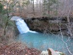
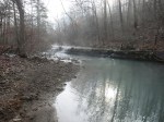
I was visiting the trails less than a week after our 5.5 inch Thanksgiving weekend rain event so in addition to puddles there were lots of waterfalls, 3 really nice ones and many smaller ones. There were at least 3 that I could hear but not see, too far down the steep slope. I think it could be interesting to follow Moccasin Creek toward its source, exploring all the tributaries along the way. I imagine there’s a lot more interesting stuff here.
I’m working on a map of these trails, though the one from the USFS is not bad. There are a couple trails they don’t show. There is a campground here and backcountry camping is not permitted. There are fees for ATV and equestrian use but apparently not for hikers. I’ll be back here to hike the western trails, if nothing else.
Dec 15 2015 update: I have a map now for the parts I’ve hiked.
-
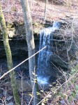
- One of the many unnamed waterfalls
-
- Stave Mill Falls
-
- Another unnamed waterfall
-
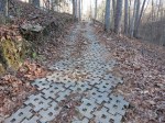
- An example of the armoring employed in some areas to reduce damage and erosion
-
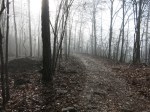
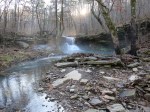
- Foggy morning
-
- Bent Tree Falls


where did you find out backcountry camping is not permitted? Can you not camp along the trail as you hike?
I might have seen it on the information board on site. I don’t see anything in the current literature that says it is not permitted.