
It’s my first hike in Wyoming and what a way to start! The Wind River Range is a 100-mile long mountain range in western Wyoming (just south of the Tetons) that includes most of the state’s highest peaks and is probably on most backpackers’ to-do list.
I went with some friends from the Kansas City area (RC, TC, and DH) for a 6 day adventure with 2 days of driving at each end. Our 32-mile loop started at Worthen Meadow Reservoir southwest of Lander and included stops at Three Forks Park, Deep Creek Lakes, Tayo Park, Stough Lakes Basin, and Twin Lakes. What they call parks here are big meadows – there are no drinking fountains nor playground equipment. Elevations were mostly 9500-10500′ with one excursion over a 11000′ pass. Morning temps ranged from 40 to 50, mostly at the higher end, afternoon highs were in the low 70s, and of course humidity was almost non-existent. We had brief late afternoon rain showers on day 1 and 3 but the skies were otherwise pretty clear. Remarkable weather overall – we hit that perfect week after the bugs are gone but before the snow falls.
The Beartooth Publishing map was very useful. It includes much more of the eastern area than does the Earthwalk Press map and it also fits nicely into a pants pocket. Conversely, it includes less of the western part.
Day 1: We start Sunday AM headed north on the Sheep Bridge trail. After a small initial climb, it was downhill for a couple miles until we arrived at the Sheep Bridge as it crossed the Middle Fork of the Popo Agie River and intersected the Middle Fork Trail. Just the day before, we were admiring the waterfalls along the Middle Fork Trail 4 miles downstream. The Sheep Bridge is pretty big – the biggest bridge I’ve ever seen out in the woods – and is all metal with 4×12″ wooden planks on the deck. I guess it has to be this sturdy because it occasionally does have cattle, and maybe even sheep, driven across it. This is open range land and we would be reminded of that a few times. We turned west on the Middle Fork Trail as it followed the river upstream to Three Forks Park. Upon arriving at Three Forks Park we were a bit disappointed to find that every likely camp site was covered with cow poop. We finally did find a site among the trees as it started to rain. I remembered the prior year’s trip in Colorado’s San Juan Mountains where every time we thought about cooking dinner it would rain. Luckily this time the rain was brief.
-
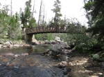
- The Sheep Bridge
-

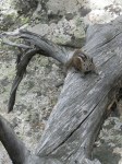
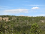
- John Mooir dropped by for a mooment before mooving on.
Day 2: As we’re finishing breakfast a herd of cattle pass by on the trail, and I can’t help feeling that a very few people are getting a heck of a lot more benefit from these public lands than are most. We head west on the Pinto Park and Deep Creek Cutoff trails, making the long climb to the Deep Creek Lakes. One of the highlights of the trip was that we spotted a bull moose here just before arriving at the first lake. It was standing in the woods on a slope maybe 100 yards away, watching as we gawked and took pictures, then lay down to show how concerned he was about our presence.
-

- Looking toward Stough Lakes Basin, where we would be in a couple days.
-

- “Yawn. Move along puny humans”
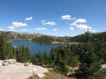
Day 3: The morning consisted of a small climb, then a descent to a lake, then repeated many times as we made our way south through the Ice Lakes area. Finally, after lunch, we have a big climb over a pass at 11000′. It was on the way up to the pass that we catch our first glimpse of Wind River Peak, Wyoming’s twelfth highest at 13192′ but the highest we would see on this trip. As we were enjoying the view some gray clouds started moving in so we skedaddled for lower elevation and made our way to Tayo Park.
-

- One of the Deep Creek Lakes
-
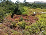
- So many colors
-

- One of the Ice Lakes
-
- Boot Lake
-

- Wind River Peak, from the pass
-

- Looking toward Sweetwater Gap, I think, from the pass
-

- Sunset over Tayo Park
Day 4: A long climb to the Stough Lakes Basin, home to 40+ lakes and a very scenic and windy place. We were at about 10500′ – near the tree line – and made camp among some stunted pine trees to get what shelter we could. It was here on Wednesday that we learned that snow was expected Saturday.
-

- Stough Lakes Basin
-

- Stough Lakes Basin
Day 5: A long descent along Stough Creek to Twin Lakes. There is a really nice waterfall shortly after turning north onto the Stough Creek Trail but it didn’t photograph well from the trail. The whole creek is a series of falls and cascades as it, and the trail, drop about 1000′ over 3 miles.
-

- Stough Creek
Day 6: Hiked out to Worthen Meadow Reservoir trail head. We had a great lunch at Gannett Grill in Lander and then started for home.
-

- Sunrise over Twin Lakes
-
- One last glimpse of Wind River Peak
This is such a large area and we saw such a tiny part of it – there’s plenty left for future trips. I think I could be quite happy living in Lander during the summer, but the winters would be much too brutal so that will probably have to wait until I win the lottery and become a nomad.
With things starting to feel more autumn-like even back home in Arkansas, I think it’s safe to say another hiking season is upon us.


Great report, ‘puny human’ 🙂
Sooo beautiful! I was moooooved! LOL