
I think it was about a year ago that I first hiked the Buffalo River Trail between highway 14 (Dillard’s Ferry) and South Maumee Road. I was with other people and we had set up a shuttle so it was a simple day hike. This time I was solo so it was a 22-mile two-day out-and-back. This part of the trail features big views from the bluffs, similar to the section upstream between Wollum Ford and Tie Slide. Of course, between those bluffs the trail drops way down to cross a creek before climbing up to the next bluff so it’s a workout. Nearer the west end of this segment, the trail also skirts around a couple large box canyons that make for some impressive scenery.
It began raining as I backed out of the driveway and continued with varying intensity until shortly after I arrived at the AR-14 trail head and prepared to hike. The day was cold, windy, and gray until the clouds parted in the late afternoon, when it became just cold and windy.
I made it to South Maumee Road with about 2 hours of daylight left so I turned around and started back. I had spotted a potentially-good camp site about a mile and a half back and figured I could make it there and still have camp set up before dark. The site had a bit too much slope for comfort but I made do. So much of the terrain on this segment is so unsuitable for camping (in a tent) that you just can’t be very picky.
The overnight low temp was 25F so it was a good test for my new Exped Downmat Winterlight mattress. I didn’t perceive any coldness from the ground so it seems to be working as I hoped.
Spring Creek is the main water source in this section and will generally be a wet crossing. A couple of the small creeks had water too but will dry up quickly after a rain.
-

- Spring Creek
-

- Looking upstream from Spring Creek Bluff
-

- Looking upstream from Stairstep Bluff

-
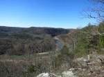
- Looking downstream from Kimball Bluff
-

- Looking upstream from Kimball Bluff
As is my custom, I celebrated another successful BRT hike with a yummy double bacon cheeseburger from Daisy Queen in Marshall.


