
For the third year in a row the big summer trip was in Wyoming’s Wind River Range. There were 5 of us this year, with RC & TC also returning for their 3rd trip and adding first-timers PD-C & CC. Like last year, we were on the west side of the range and based out of Pinedale. We started north of there at New Fork Lake on a 7-day, 40-mile route that included Lozier, Clark, Peak, Elbow, Twin, Summit, No Name, Cutthroat, Palmer, and Rainbow Lakes. This basically takes us east for about 3 days toward the central part of the range, then south for about 1, and back west for 3 days.
There had been a bit more snow this past winter so the season was running a bit late. Consequently, the wildflowers were near their peak this time instead of just past, and we encountered more bugs. Overnight temperatures were mostly in the 40’s though we dipped below freezing the first night. The weather was mostly great with rain much of the morning of day four and a few other scattered brief showers.
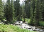
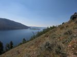
Day 1: New Fork Lake trail head to New Fork Park. We hike alongside the lake and then follow the New Fork River up through a canyon filled with great scenery and tasty Thimbleberries, then take a left turn into New Fork Park, a large meadow where we camp at about 8800′. Along the way we pass fairly close by a moose that is trying to hide behind a tree. We only climb about 800′ in elevation but shortness of breath is the theme of the day as we all try to acclimate to the altitude. It is Sunday and we see quite a few people hiking out, their trip nearly complete.
-

- A look back at New Fork Lake
-

- A look ahead at the canyon through which we’ll be hiking
-

- The first crossing of the New Fork River
-
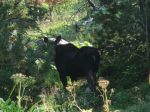
- The moose
-

- Hiking into New Fork Park
-

- The first night’s camp
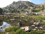
Day 2: New Fork Park to Lozier Lakes. More climbing – through a pass at about 10700′ before descending a little to Upper Lozier Lake. After moving above the tree line we marvel at the abundant wild flowers.
-

- A nice place for lunch

-

- A look back at New Fork Park, where we began the day

-

- One of many pika we saw

-

- A final look back at New Fork Park
-

- Lozier Pass
-
- Upper Lozier Lake
-
- CC filters water
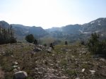
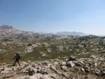
Day 3: Lozier Lakes to Trail Creek Park. We begin the day with a descent past Lower Lozier Lake, a climb to Clark Lake Pass, then a long descent to Clark Lake at 10250′ where we stop for lunch. We meet a man from Lawrence KS near Lower Lozier Lake. After lunch, it’s more downhill until we cross Trail Creek (which becomes the Green River further downstream) at about 9300′. We see 2 more people. We turn south on the Continental Divide Trail and begin climbing again, looking for a camp site and finally finding one just past the junction with the trail going to Vista Pass.
-

- Clark Lake Pass and the interior of the Winds
-
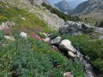
- Wildflowers galore
-

- Clark Lake
-
- Green River, near the head waters

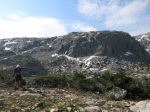
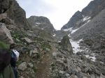
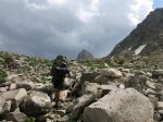
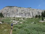
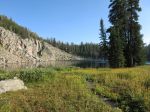
Day 4: Trail Creek Park to Peak Lake. While eating breakfast we hear an elk bugle nearby. We start the day by climbing from about 9600′ on a no-longer-maintained trail through Vista Pass at about 10200′, then down into the next valley to about 9800′ before climbing again toward Cube Rock Pass at 10740′. We scramble for 1/4-mile over the remnants of a landslide – the first time any of us have done this with a full pack – followed by traversals of a couple snowfields that, while not difficult, did certainly focus the mind on not making a long slide to the bottom. We all agree that this is some of the toughest hiking any of us have done. Once through the pass, we descend to a campsite at about 10600′ overlooking Peak Lake. We set up camp in a hurry, thinking we are going to get dumped-on but the rain holds off. We watch a group of three descend from Shannon Pass (where we will ascend tomorrow). They camp elsewhere along the lake. Near dusk another hiker on a 14-day trip shows up.
-
- Descending from Vista Pass
-

- A look back…
-

- …and a look ahead at the path to Cube Rock Pass
-
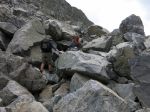
- A 1/4 mile scramble though the boulders…
-
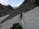
- ..followed by traversing a couple snow fields.
-
- It’s clear sailing now to Cube Rock Pass, if only we could breathe
-
- The final climb to Cube Rock Pass
-

- The road ahead, from Cube Rock Pass
-

- Peak Lake, at last
-

- Shannon Pass, where we’ll start the next day
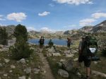
Day 5: Peak Lake to Summit Lake. It begins raining as we climb toward Shannon Pass at 11180′ – our highest elevation for the trip. Much of the distant scenery is obscured by clouds. We descend and turn west – marking the beginning of the return trip – as we make our way around the Elbow Lakes, and past Twin Lakes to our camp at Summit Lake at about 10350′.
-

- A look back at Peak Lake during the ascent to Shannon Pass
-

- Near the top of the pass, with rain clouds swirling
-

- Another snow field, this one not so steep
-

- The Elbow Lakes come into view
-
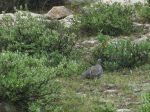
- A Ptarmagin


-

- A bridge over Elbow Creek
-

- Elbow Creek
-

- Sunset at Summit Lake
Day 6: Summit Lake to Rainbow Lake. 2 people hike past Summit Lake in the morning, heading north on the CDT. We’re getting some smoke from Idaho wild fires and my eyes and sinuses burn. We’re expecting this day to be small elevation changes but the ups-and-downs are bigger than expected as we pass No Name, Cutthroat, and Palmer Lakes. Add in a lot of sun exposure and this turns out be a pretty tough day. We end at Rainbow Lake @ 10190′. A lone man shows up around dinner time and skinny-dips in the lake.
-

- Sunrise at Summit Lake
-

- Approaching the first of the No Name Lakes
-

- Looking back at Palmer Lake

-
- Rainbow Lake
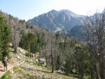
Day 7: Rainbow Lake to New Fork Lake trail head. It’s downhill almost all the way, first through a nicely wooded area but then we get into an area that burned about 6 years ago. As we descend through the burn I spot a flashlight and contact lens case laying on the trail. The lens case contains a small amount of marijuana. Someone is gonna be really bummed out when they discover it’s missing.
We emerge from the burn into the flat area along the New Fork River at the head of the lake and make our way across. There’s no obvious trail on the other side but as we’re putting our boots back on I spy a place upstream where it looks like a lot of traffic has been going up and down the bank. I figure that’s the trail but getting to it requires changing shoes again and there’s a pizza buffet calling out to us so I decide I’ll just bulldoze a path 50′ through the willow thicket and then go 100 yards cross-country to the trail. Just as I was about to break through the far side, I encounter a small marshy area at least a foot deep and too wide to jump. We back up and head in another direction when TC gets stung multiple times near the eye. We beat a retreat to the river with tails between legs and make our way upstream to where we should have crossed in the first place, sure that this delay has cost us our pizza buffet. Lesson learned: stay the hell out of the willows!
I leave my recently-acquired stash in the trail head parking lot next to a car that looks like the occupants will appreciate it. We are about 30 minutes late for the pizza buffet but the waitress, apparently sensing our distress, or maybe just fearing our trail aroma, agrees to let us do a buffet anyway. A perfect ending.
-

- Descending through an old burn

Of course, discussion of next year’s trip began before this one was even over.
11-20-17 update: Curtis C posted a nice 17-minute video summarizing our trip.


I hope you are making an album of your writing and photos. Your photo are out standing.
Thanks! I’m certainly not throwing any photos away.