
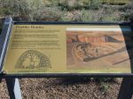
Chaco Culture National Historical Park encompasses an important collection of ancient Puebloan ruins in NW New Mexico’s Chaco Canyon and a visit here has long been on my to do list. A big difference here as opposed to places like Canyon de Chelly is that you can see the ruins up close and generally even walk through them. I took 350 photos here over a day and a half and only 100 over 3 days at the Grand Canyon so I guess that says something.
The area is well off the beaten path and the National Park Service, which operates the site, recommends coming in from the north via US550 rather than from the south so that’s what I did. Most of the road was fine but as NPS notes the last few miles were very rough indeed – the worst washboarding I’ve ever encountered – and it seemed like it would never end.
Several of the sites are near the park road but a few require a bit of hiking, I recommend buying the guide books at the the visitor center. Backcountry Trail Guide covers the 4 longer hikes: 5 mile Pueblo Alto Trail, 7.2 mile Peñasco Blanco Trail, 3.6 mile South Mesa Trail, and 3 mile Wijiji Trail. Individual guidebooks for sites near the road include Pueblo Bonito, Chetro Ketl, Pueblo del Arroyo, and Casa Rinconada.
I stayed about a day and a half with one night in the campground. I think seeing everything would probably require 3 days. The park closes at 4:30PM, and they expect everyone to be off the trails and outside the main gate by that time so it really cuts into the available hiking hours. Potable water is not available in the campground but there is a hydrant at the Visitor Center that can be used (when they’re open).
Fajada Butte is the site of the famous Sun Dagger petroglyph and alleged solar calendar. Access is no longer permitted due to damage that’s been done over the years.

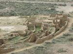
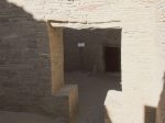
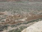
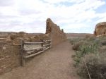
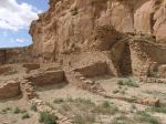
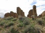
Pueblo Bonito is the largest of the Great Houses and the icon for this whole area. It was built in stages from about 830 to 1150 CE and you can plainly see how the construction techniques and style evolved over time. It is thought to have been 4 or 5 stories tall but the current ground level is just above the second floor. Much of the building had apparently been covered by sand so extensive excavation has been done in recent years.
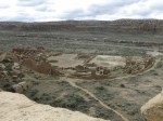
Here are photos from taken from above on the Pueblo Alto Trail:
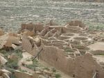
The guidebook describes a 19-point self-guided tour. Wood used in the construction came from about 50 miles away and was helpful in dating the various phases of construction via dendrochronology.
-
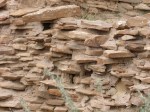
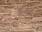
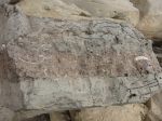
- Some of the oldest masonry – rather crude.
-
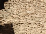
- Newer masonry – more refined.
-
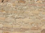
- The newest masonry – nice!
-
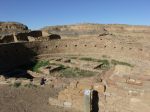
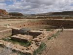
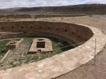
- One of the great kivas.
-
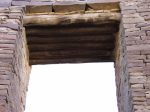
- A typical door, with timbered lintels.
-
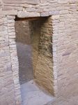
- One of the other door styles
-
- and another door style
-
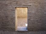
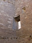
- One of the T-shaped doors
-
- One of several angled doors, above remnants of supports for the 3rd floor
-
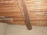
- This room had some of the original ceiling/floor (with new plaster to cover graffiti)
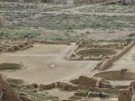
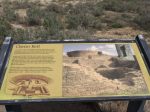
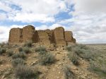
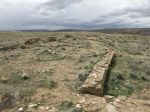
Chetro Ketl is the second largest of the Great Houses and was built between 1000-1100 CE. It lies .25 miles east of Pueblo Bonito and is also visible from the Pueblo Alto Trail on the bluff above. The Petroglyph Trail runs along the base of the bluff and connects the two sites.
-
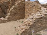
- A look at the “core and veneer” technique for building walls
-
- The Great Kiva
-
- The Great Kiva
-
- Looking along the back wall
-
- Detail of the wall veneer
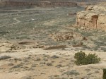
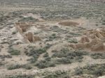
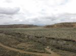
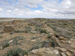
The 5-mile Pueblo Alto Trail passes behind the ruins of Kin Kletso (about .5 miles NW of Pueblo Bonito) and climbs through a big crack to the top of the bluff – the same route used by the ancients during their travels. The guidebook describes many points of interest along the way but I’ll show only a few here. Pecked Basins were carved on some ledges and some contained pieces of turquoise so they may have been used for offerings. The trail passes the ruins of New Alto and Pueblo Alto with a bit of the Great North Road in between. The road runs 40 miles straight north to a canyon just west of Angel Peak. Also visible is part of a stairway carved into the bluff face for travel between the canyon and the plain above. There’s plenty of interesting geology on display too like the “shrimp burrows” where ancient crustaceans dug tunnels through the sand which were later filled with iron-rich deposits.

-

- Kin Kletso
-

- An ancient path to the bluff top
-
- Looking down the south canyon
-

- Pecked Basin
-
- New Alto
-
- New Alto
-

- The Great North Road
-
- Pueblo Alto
-
- Pueblo Alto
-
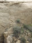
- The stairway
-
- Shrimp burrows
The other sites I was able to visit this time were Pueblo del Arroyo, Hungo Pavi, Casa Rinconada, Una Vida, and Gallo Cliff Dwelling. On the surface, they’re more of the same. There are interesting details but this post is already pretty long so go see them for yourself.
Funeral for a friend. Strong winds developed in the afternoon of my first day in Chaco and about 10 minutes after I got back to my campsite the wind tore loose 7 of the 8 stakes holding my Big Agnes Copper Spur. I was able to grab the tent before the last stake gave out and the whole thing went airborne but not before the wind beat it mercilessly against the rocky ground and vegetation, tearing the hell out of the rain fly and bending the majority of the tent pole sections. It didn’t rain so I managed to get through one more night in it but I’m afraid it was the last trip for this old friend. It served me well. B:Dec 2011, D:Apr 2019.
This was the last stop on my great southwest adventure. I hiked in 4 new states, saw lots of interesting stuff, and crossed a couple things off the bucket list. I was very surprised to have decent weather for the whole almost-2-weeks.


