Wind River trip #6 is in the bag. I and 3 of the usual suspects (RC, TC, & PDC) did a 6-night 35-mile “lollipop” (Aug 29 – Sep 4 2021) that took us past Toboggan, Little Divide, Lightning, Dream, Bobs, Sandpoint, Middle Fork, Rainbow, Dream, Raid, and South Fork Lakes, and then out past Lightning, Little Divide, and Toboggan Lakes again. We spent an extra day at Middle Fork Lake with a day-hike up to Donna Lake at the base of Pronghorn Peak.
Useful resources include Beartooth’s South Wind River map, Nancy Palister’s “Beyond Trails in The Wind River Mountains” and Ben Adkison’s “Hiking Wyoming’s Wind River Range“
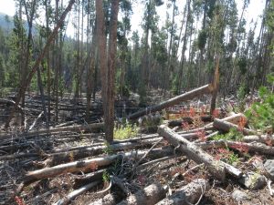
Last Labor Day weekend this area was hit hard by a storm that left many trees down, and many hikers trying to find a way out of the wreckage. It was pretty sobering to imagine myself in that situation. We encountered a small pile of trees up the Sandpoint Lake inlet but everything else had been cut. My hat is off to all the USFS folks that cleared those many miles of trail.
Day 1: After a restful night at the Log Cabin Motel in Pinedale and a filling breakfast at the Wrangler Cafe, we drove to the Scab Creek trail head (8200′) and began hiking in on the Scab Creek Trail (#110). The trail climbs about 1300′ into the Toboggan Lakes area and then does a lot of small ups and downs on the way to Little Divide Lake. We were in the woods all day with only a few opportunities early on for a view – to the west. The Wyoming Range was lost in the haze.
It’s a Sunday so we met many people coming out. A couple people, upon hearing that we were headed to Middle Fork Lake, told us about a tent that was apparently abandoned at Lee Lake.
We camped on a bench above the northern outlet of Little Divide Lake (9623′). The water had a strong tannic taste.
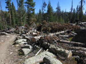
An area hit hard by last year’s storm 
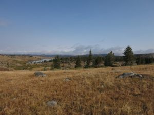
Entering the Toboggan Lakes area 
Little Divide Lake
Day 2: From Little Divide Lake the trail climbs past Lightning Lake to about 9900′ before dropping a bit as it nears the South Fork Creek crossing. We broke out of the trees with a view to the north and east just in time for a rest stop. It was still pretty hazy but we welcomed the opportunity to finally get a glimpse of our destination. We can see that we’ll soon be out of the trees for a long while.
Another person hiking out told us about the abandoned tent at Lee Lake. Nobody we spoke with looked inside. We wondered if there was a body in it.
We descended a little more and turned NE onto trail #167, crossed South Fork Creek, and made our way to Dream Lake (9900′) for lunch. Then we caught the Fremont Trail north past Bob’s and Sandpoint lakes, then trail #157 NE up Middle Fork Creek. After a couple miles we found a good camp site in a little bowl about 50′ above the creek (10000′).

Our first view of the peaks and a nice place to rest. 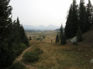
Descending into the South Fork Creek drainage. 
Dream Lake, looking south. 
A not-great picture of the sandy point at Sandpoint Lake. 
Crossing Middle Fork Creek at the inlet of Sandpoint Lake.
Day 3: We continued up Middle Fork Creek about 2.5 miles to the outlet of Middle Fork Lake (10252′). From there it was about 2 more miles to get around the north side to near the inlet. There are a variety of paths to choose from but I think they all require some amount of battling with the willows.
We originally had the notion of doing a day hike up to Bewmark Lake (10765′) and then on to Photo Pass (11430′) but as we looked at the climb required to get up to Bewmark we decided to do something else with our “off” day.
We arrived at our camp site on the north side of the Middle Fork Lake inlet in time for a late lunch. The haze seemed to be clearing in the north and east. A couple of us went to reconnoiter Lee Lake (where they did spot the mysterious abandoned tent) while I stayed behind in a small bit of shade and rehydrated. The haze in the west created interesting sunset scenes.
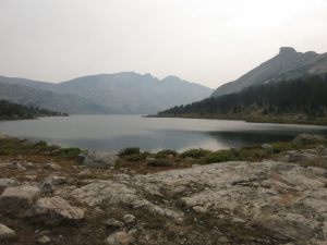
Middle Fork Lake, backed by Kagevah Peak. 
Approaching the inlet of Middle Fork Lake, with a hazy Pronghorn Peak just left of center and Dragon Head to its right. 
Sunset over Middle Fork Lake. 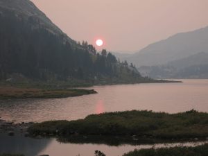
Sunset over Middle Fork Lake.
Day 4: Our scheduled layover day began with some haze and overcast skies. We decided to hike up to Donna Lake (11060′), at the base of Pronghorn Peak (12388′).
We passed right next to the abandoned tent and called out but there was no reply. It was an expensive tent – a pyramid made of DCF – so it seemed strange that somebody would just leave it. We moved on without investigating further.
There was a pretty clear path along the east shore of Lee Lake but we lost it about halfway down the lake and began boulder-hopping and willow-whacking to make further progress and gain the needed altitude. We finally broke out into the saddle below Donna and then scrambled up the last eighth-mile and 200′ elevation. Getting close-up to that 1000+’ vertical face of Pronghorn Peak was pretty cool. We wondered if Jimmy Chen could climb it. We realize that getting to Photo Pass might not have been much more work than we just did.
The ridge east of Donna Lake leads to the pass into Bonneville Basin and while we were there we met one group heading to and another coming from. After lunch we started back to camp as the sky grew cloudy.
Back at the inlet of Lee Lake, the abandoned tent was still there and our calls still received no reply. We decided we had to look inside and report this to the Forest Service. Someone bravely unzipped the tent and inside was a lot of gear but no body. It was like the person just walked away and left everything behind. We took some pictures to add to our report, zipped the tent and started walking away. I happened to look toward Dragon Head as something big flew off it and circled toward us – a parasail! – before landing 100 yards away. After 3 days of climbing Dragon Head only to be stymied by the wrong winds, we happened to be present for this dude’s first successful flight. He said it was the first time anyone had flown off Dragon Head. I told him we thought maybe he was dead. He, of course, had no idea he was the subject of such fevered speculation and said we were the first people he had seen up there. Mystery solved.
Finally back at camp, a storm moved through. The winds were strong enough I felt like I needed to hold on to the tent poles to keep them from going anywhere while at the same time wondering if that’s a bad idea with all the the lightning. We had a few hours of decent weather afterward and then more rain about the time we went to bed.

Less-hazy Pronghorn and Dragon Head peaks. 
Pronghorn and Dragon Head peaks looming over Lee Lake. 
The approach to Donna Lake. 
Looking back over Lee Lake (foreground), and Middle Fork Lake (background). You can also see Odyssey Peak and Photo Pass if you know where to look. 
Donna Lake! 
Pronghorn Peak above Donna Lake. 
The dude parasailing from Dragon Head. 
The pass we will go through tomorrow on the way to Rainbow Lake.
Day 5: We woke to find last night’s rain frozen on everything. After breakfast I set to work scraping the ice off my tent with an old credit card. We eventually got some sun to thaw and dry the rest. The objective for the day is to hike over Middle Fork Pass (11020′) past Rainbow and Dream lakes to the south end of Raid Lake.
As we approached Rainbow Lake (10369′) we could see rain envelope the mountains behind us and we were glad to have gotten through the pass ahead of that. While having lunch at Rainbow Lake a sudden blast of wind announced that the rain had caught up with us. By the time we got our raincoats and pack covers in place and packed our stuff the rain stopped. We continued toward Dream Lake, where we caught the Fremont Trail SE to Raid Lake (9945′). It was about then that it started raining again and this time it wouldn’t let up for several hours.
We went as far as Raid Creek before finding a place to camp with accessible water. The others set up camp in the rain. I took so long to decide on a site that the rain stopped. The clouds cleared in the west and graced us with sunshine all through dinner. After going to bed we heard coyotes howling and an occasional elk bugle. Then it rained again, of course, but just briefly.

Approaching Middle Fork Pass on our way to Rainbow Lake 
In the pass, looking back… 
… and forward to Lake 10575 and Rainbow Lake 
The island in Rainbow lake
Day 6: I got out for my morning poop and noted it felt like it could rain again. By the time I got back to my tent it had started. It slowed after about 30 minutes and we decided to just get packed up and go. Naturally, by the time we finished packing it had stopped. We continued a short distance down the Fremont Trail and once we broke out of the trees we headed west cross-country to intercept the Highline and/or Scab Creek Trails. This area is a huge meadow that we shared with a herd of cattle.
We did end up hitting the Scab Creek Trail and turned NW past South Fork Lake (9937′) into the South Fork Creek drainage and territory we covered on the way in. We made our way past Lightning and Little Divide lakes and made our final camp in a well-used area near one of the Toboggan lakes. We had ample time before dark to dry our gear once again, had our first and only camp fire of the trip, and enjoyed a night with stars instead of rain.
The southern tip of Raid Lake with the vast meadow surrounding it. 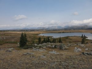
South Fork Lake 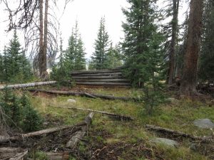
The remains of an old cabin
Day 7: We awoke to sunshine and mostly-dry tents and enjoyed breakfast with a view of the lake. The hike out was uneventful. We especially enjoyed the final 1.5 miles – where the trail is downhill all the way to the trail head. We once again passed through one of the areas most heavily damaged by last year’s storm and marveled at the work done to clear the trails.
We drove south with a stop at the Farson Mercantile for lunch (a pulled-pork sandwich and chocolate milkshake for me). Highly recommended! Talk about trip #7 has started, and llamas have been mentioned.

The Wyoming range is still lost in the western haze. 


Man, for a minute there I thought you weren’t going to look in that tent. The story had an interesting ending in spite of the lack of a dead body.
The link to the Log Cabin Motel isn’t working. I think https needs to be http.
Glad you were able to do your trip out west again.
Brad
On Tue, Sep 14, 2021 at 10:07 AM The Compulsive Hiker wrote:
> Michael R posted: ” Wind River trip #6 is in the bag. I and 3 of the usual > suspects (RC, TC, & PDC) did a 6-night “lollipop” (Aug 29 – Sep 4 2021) > that took us past Toboggan, Little Divide, Lightning, Dream, Bobs, > Sandpoint, Middle Fork, Rainbow, Dream, Raid, and Sout” >
Thanks, I tried to create a bit of suspense re the mystery tent. 🙂 I got the URL fixed.