
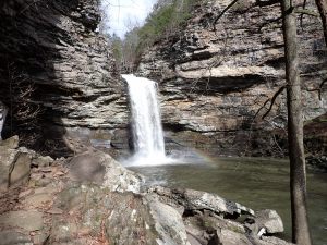
Petit Jean State Park was Arkansas’ first state park. Several trails can be combined for hikes of varying lengths up to about 12 miles. Highlights include Cedar Creek Canyon, Cedar Falls (95′), Rock House, and the falls and grotto in Seven Hollows.
Here are reports from Aug ’14, Sep ’14, and Nov ’14 trips.
If you’re interested in an overnight stay, PJSP has tent camping areas, cabins, and a lodge (with a restaurant). It even has an airstrip (MJP) if you want to fly in.
Trail Maps
My maps are in a 2-page PDF and are sized for 8.5×14″ (legal) size paper. Note they are at different scales. Here’s some general info about my maps. Every time I update the map the file will have a different name so if you want to bookmark or share it, link to this page – not the file.
v7, Oct 19 2025: Fixed the routing of the BSA Trail in the area of Turtle Rocks/ Rock House. The overlook on the north side of the canyon in that area has been removed from the map as it’s now in a “don’t go there” area.
v6, Jan 28 2025: Minor style updates.
Nov 8 2023 update: An all-new base layer replaces the old scanned USGS topo maps. Much nicer looking and more usable.
Trail heads
Seven Hollows 35.1142°N 92.9454°W
Bear Cave 35.1151°N 92.9445°W
Mather Lodge 35.1174°N 92.9380°W
Cedar Falls Overlook 35.1204°N 92.9334°W
Pioneer Cabin 35.1207°N 92.9294°W
Rock House 35.1232°N 92.9369°W
Trails
The Bear Cave Trail is a 0.25 mile loop (with part of the BSA Trail) through a rock outcropping next to the Bear Cave trail head. Good scenery.
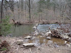
The BSA (aka Rockefeller Boy Scout Trail) is a 6.2 mile loop that circumscribes much of the western part of the state park and intersects all the other trails. Can be combined with the Cedar Creek (+1.1 mile) & Seven Hollows (+3.6 miles) trails if you want more. The lower Cedar Creek crossing is on stone steps and it doesn’t take much rain to get the creek up enough for the stones at the north end to be under water so always be prepared for a wet crossing. Accessible from all trail heads.
The Canyon Trail runs 1 mile alongside Cedar Creek through the Cedar Creek Canyon. Connects Cedar Falls & BSA trails, basically bisecting the BSA Loop.
The Cedar Creek Trail is a 1.2 mile loop connected to the eastern end of the BSA trail. Runs alongside Cedar Creek well above the falls and crosses it twice (on bridges). Feb ’25 update: A new bridge has been installed at the upper (eastern-most) crossing.
The Cedar Falls Trail runs 1 mile to the waterfall. Begins behind the lodge and drops 300′ down the hill, crossing Cedar Creek on a bridge at 0.4 miles near the junction with Canyon Trail. Very scenic!. Does *not* connect to the BSA Trail on north side. The only way out is to backtrack to the lodge or head west down the canyon.
The Rock House Cave Trail is a 0.2 mile spur from the parking lot to a large bluff overhang. It intersects the BSA Trail.
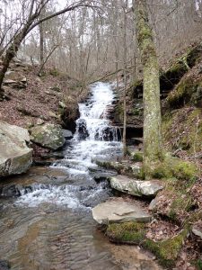
The Seven Hollows Trail is a 4.25 mile loop with lots of interesting geology – long blufflines, a natural bridge, many caves, Seven Hollows Falls & grotto, turtle rocks, etc. A favorite of many who see it.
Photos
Last review/update: Oct 29 2025


Where can I buy a copy of these two Petit Jean maps?
They aren’t for sale anywhere, but you can download the files and print them yourself or have then printed at The UPS Store or an office-supply store.
I used to live in Arkansas and there is a point out where I lived (Billy Goat mountain area) where you can see the top of Pettit Jean Mountain. Granted it’s well off in the distance. And I was wondering if any of the outlook points face eastward? I went back to Arkansas after being gone for 20 plus years and visited the mountain but I didn’t have a compass to tell me the direction of the viewing area. I was just curious if I can make out that area I lived in from any of the Lookout points.
Sorry for the delay but I was enjoying some scenery in Wyoming. The area with the supposed grave site of Petit Jean (Stout’s Point?) faces east.