
This is a summary of 2 recent trips to Petit Jean State Park to hike some trails I didn’t cover on the first visit, plus a bit of volunteer work.
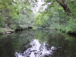
The Cedar Creek Trail is a 1.25 mile loop beginning at the Pioneer Cabin. You’ll cross the creek twice on bridges. There is some nice scenery in this area. The water was unusually high and distinctly brown on this trip because Lake Bailey upstream was being drained. This trail connects to the BSA trail on both side of the creek. On the north side, it goes downstream to Rock House Cave and beyond (see below). On the south, it goes through the Cedar Falls overlook, Mather Lodge, the Bear Cave area, and beyond.


The portion of the BSA trail on the north side of the creek between the Cedar Creek trail and the Rock House Cave area has some interesting features as it climbs along the bluff opposite the Cedar Falls Overlook. There is a man-made overlook on this side but trees obstruct the view of the falls. There is a ledge a bit further downstream with better views but if you really want to see the falls, you need to head down the Cedar Falls trail.


One of the most-used trails in the state, the 1-mile Cedar Falls trail begins at the Mather Lodge. Head through the breezeway, down the steps, and to the left. About the first 1/3 mile switchbacks steeply down hill on a lot of CCC-built stairs. At about .5 miles you cross the Cedar Creek bridge to a junction with the Canyon Trail. Head right to the falls, about another .5 miles. On this trip, water flow had returned to normal so I don’t have any dramatic pictures of the falls. It is possible to make your way behind or underneath the falls.


The Canyon Trail runs about 1 mile from its junction with the Cedar Falls Trails downstream to the Blue Hole area – an old swimming hole with a CCC-built dam/bridge and the nearby remains of a changing house. At the Blue Hole, you can turn north on the BSA Trail to head up to the Red Bluff area or south on the BSA Trail to head up the hill, across the highway, and east towards Seven Hollows. It’s a climb either way.


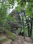
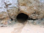
I took the south loop this time, across the northern part of the Seven Hollows Loop to the Bear Cave area. There are a lot of interesting rocks here and some views of the canyon. The cave is really just a shallow opening in the rock – perhaps eroded by swirling water ages ago.


I still haven’t hiked the north part of the BSA Trail, but maybe next time?
Finally, I signed-up as a park volunteer to help maintain trails here and had my first work day today with the target being the Cedar Falls trail. 4 of us, including 2 rangers, lopped some brush and poison ivy, cleared a tree from the trail and picked-up trash. We filled a 13-gallon trash bag and 2 plastic Walmart bags, mostly with plastic water bottles. I just don’t get it.


