
Located just a bit northwest of Little Rock is Pinnacle Mountain State Park, featuring the highest member of a mountain chain called the Maumelle Pinnacles. Pinnacle Mountain is only 1011′ in elevation but it rises rather sharply from a base at about 300′ so it has a pretty good elevation change and is very prominent. Other nearby features are the Arkansas, Big Maumelle, and Little Maumelle Rivers plus Lake Maumelle.
There are two trails to the top – West Summit and East Summit – both about .75 miles in length. The Base Trail is a 3.5 mile loop around the base of the mountain that also connects near the beginning of the summit trails. My plan was to ascend the West Summit Trail, descend the East Summit Trail, and then traverse about half of the Base Trail back to the parking area.
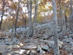
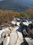
The West Summit Trail is pretty much a masterpiece of rock work with a lot of carefully fitted steps to about half way up. Then you enter the boulder field that is the top 40% of the mountain. Here the trail is blazed on the rocks and the boulders seem to have been moved around a bit to provide some steps while still looking very natural.

At one point the trail splits with the left branch being longer but gentler. I took the right branch, naturally. Finally you get to the top. You can veer left to the slightly lower north peak or turn right to the taller south peak. Both have commanding views of the area.
-
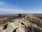
- The north peak of Pinnacle Mountain with the Arkansas River below
-
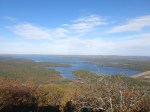
- Lake Maumelle
-

- Looking west at the rest of the Maumelle Pinnacles
The West Summit Trail was moderately challenging physically, but fairly simple technically. Descending the East Summit Trail proved to be a very different experience. There was no grooming of the trail here and every footstep had to be planned.
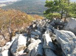
Once you get about halfway down you leave the boulder field and the trail becomes a typical walk in the woods, without all the stone work found on the lower half of the West trail.
It’s possible that my differing views of the East and West trails are simply due to ascending versus descending, but I don’t think so. I’ll have to get back out there again to go up the East and down the West to compare, I guess.
After conquering Pinnacle Mountain, I headed to the visitor center to check it out and to hike the nearby Rocky Valley & East Quarry trails. Rocky Valley is a 2 mile lollipop with a 0.5 mile spur that is the East Quarry Trail.
Rocky Valley starts at an old quarry near the visitor center that is probably considered the West Quarry.
 It heads south for a while and then turns east into a big loop across a rocky hillside. At the furthest point of the loop is the East Quarry spur. Near the end of that, at the base of the quarry, is a nice scenic vista with a bench. The trail continues a little farther, climbing up around the back side of East Quarry to another vista.
-
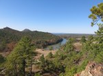
- Maumelle River, downstream from the lake & dam. That’s Pinnacle Mountain about 1/3 from the left edge.
-

- A closer look at Pinnacle Mountain.
Back at the lower vista, one has views of the Arkansas River on the right, Lake Maumelle (far left), and the Maumelle River (near left) just before its confluence with the Arkansas.
 Another very important feature of this park is that it’s the eastern end of the 223-mile Ouachita Trail. I’ve seen both ends and hiked fragments totaling maybe 10-12 miles but am now deep into planning a full-on assault. Coming soon!
 I stopped by Mustang Sally’s in Perryville on the way home and the women there really satisfied my needs!


