
Section 4 of the Ouachita Trail is almost complete. I’ve gotten as far west as the Foran Gap Shelter, less than a mile east of the US-71 trail head.
I left off at mile 91.4 last time, and headed back out there March 6 to continue. The plan was to park at the FR 76 trail head at about mile 88.2 and hike east to 91.4 and back, then west to US-71 and back over the three day weekend, about 47 miles.
There was still snow on the ground from a recent bout of wintry weather so I wore my waterproof boots – for the first time in several months – and that turned out to be a big mistake as they were no longer actually waterproof and my feet were no longer conditioned for them. By mid-afternoon I was only at the road to Buck Knob – about mile 85.7 – behind schedule, with feet wet, blistered, and hurting, all my energy and snacks gone from slipping and sliding in the snow, and thinking I probably didn’t have enough water to get where I needed to be. I decided to bail out, making it yet another weekend trip that turned into a day hike.

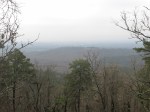
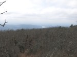
Looking roughly southwest from the vista at mile 86.2.
Fast forward to this weekend, and the forecast called for periods of light rain Friday (3/13) and maybe some drizzle Saturday morning and that seemed tolerable but as I drove south to continue my hike west, I ran into some torrential rains that didn’t seem like they were going to stop any time soon so I turned around and went back home. Good thing too, because it did rain most of the day.
Saturday’s forecast still looked decent so once again I headed south with intermittent drizzle and fog. This time I parked at the road to Buck Knob – FR76A – and planned to hike west to US-71 and back. This stretch of trail is all on or near the top of a ridge and features about a 900′ climb to the high point of Blue Mountain at 2623′ and many, many smaller ups and downs. Since the trail is relatively high here, there is typically no water except at Tan-A-Hill spring (mile 74.2). On this trip, however, finding water would be no trouble at all.
Around 11:30 the fog and drizzle started clearing, as forecast, but then it clouded over and started raining lightly and kept it up until well after dark. I got to the Foran Gap Shelter (about mile 68.9) at 6:30 PM and was so glad not to have to set up the tent and cook dinner in the rain, and then sleep surrounded by all my wet stuff. My feet were seriously pruned due to being wet all day but they got over that. The overnight low temperature was 52 so the weather people got that wrong too, but in my favor this time.
Sunday dawn brought some sunshine and the promise of a nice day. The high humidity overnight meant none of my stuff got any drier, and there were still lots of puddles on the trail so my feet were very soon wet again. I wasn’t looking forward to going back over Blue Mountain but I figured I would have the opportunity to see the views that were shrouded in fog on the way out and hoped it would be worth it. It got foggy again as I started back but then cleared as I got up to the areas that looked promising for scenic vistas, so I was able to get some pictures after all. The toughest part of the whole trip turned out to be the climb out of Turner Gap on Sunday. It’s only about 400′ up but with the sun bearing down and the afternoon heat peaking (>70 degrees) it really beat the crap out of me. Soon after getting past that the sky clouded a bit and made it feel cooler so that helped with all the remaining ups and downs.
I started hiking earlier Sunday figuring I would get back to the car earlier but it turned out to be later – about 6:50 PM – making it a heck of a long day. I made it to the Subway in Mount Ida 5 minutes before they closed so I was able to get some food and caffeine in my belly before the seemingly-long drive north to home.
I didn’t make it the extra 0.8 miles to the US-71 trail head this time so that will be part of the next trip. To the west are Rich Mountain, Winding Stair Mountain, and some much bigger climbs before I reach the end. I wonder if I’ll be able to finish before the weather gets too hot? 3 more weekends just might do it.
-
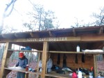
- Ryan and Alec – my “bunk mates” prepare their breakfast.
-
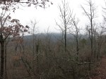
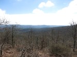
- Blue Mountain looming in the distance.

-

- The first of many ‘Spring Beauty’ I saw. A sign of things to come.
-
- Irons Fork Lake
-

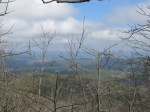
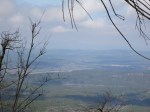
- That’s probably Rich Mountain and Winding Stair Mountain in the distance. A couple more big ones that need to be climbed.
-
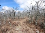
- The taller mountains are capped with scraggly lichen-covered oak trees that are probably much older than you would guess.

-

- I saw a few of these trees with rocks in their crotch.


Yeah, the climb and those briars from mm 80 – 75!