
Here are some more waterfalls I wouldn’t have known about without Tim Ernst’s book. About 13 miles north of Scottsville AR, along North Fork Road (FR 1310) are a couple that are pretty close to, but downhill from, the road. “North Fork” refers to the North Fork of the Illinois Bayou, which runs roughly parallel to, but about 500′ below this road.
The South waterfall measures 33′ and the North is 53′. It’s easy enough to see the top of the falls, and to get around a bit to the side to see the whole thing in profile but this is steep terrain so getting down below for a good look requires some effort. As usual there are smaller falls nearby. These are rather high up so the water flow doesn’t last long after a rain, and there wasn’t much more than a trickle today.
Parking for the South Falls is at 35.57059, -93.01966. I came down the north side through a break in a ledge. A smaller waterfall becomes visible downstream once you get down below the big one. I tried getting below the smaller one on the north side and got stuck on a ledge. I’ll try from the south side next time.
-

- Looking at the top of the falls from the road
-
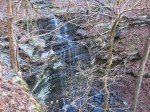
- The easy profile shot
-
- Looking back up at the main falls from the top of the smaller fall.
-
- Looking down at the smaller fall from my perch above.
Parking for the North Falls is about .6 miles further north at 35.57610, -93.01862. Here, there are smaller falls both up- and down-stream of the main fall. I got below the main fall on the south side and then crossed the creek to get below the smaller one on the north side, but once again got stuck on a ledge. I’ll have to try the south side here too next time, but I could see it’s kind of a long detour.
-

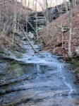
- The small waterfall upstream of the main one.
-

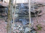
- The easy profile shot.


-
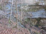
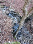
- A bad picture of the small waterfall downstream.


