
The Womble Trail runs southwest for 37 miles from its intersection with the Ouachita Trail near mile 117 to North Fork Lake south of Oden. Legend has it that it was originally intended to be part of the Ouachita Trail before a reroute moved the OT further north. Nowadays, it’s mostly known as an IMBA Epic mountain bike trail and home to the Ouachita Challenge.
I hiked the northernmost 3.5 miles last January so this time I hiked from there to mile 24, just past the AR-298 trail head. I had no shuttle so it was about 41 miles out-and-back. The trail is well-maintained and plentifully blazed. The terrain is mostly gentle with several dependable-looking water sources like Big Branch, West Spring Creek, and Fulton Branch.
Right in the middle of this section the trail crosses the Ouachita River on the wide shoulder of the new AR-27 bridge. Both north and south of this crossing, the trail climbs onto bluffs that look out over the river. The north bluff is about a 200′ climb while the southern is about 400′, so they’re pretty gentle compared to other Ouachita trails.
So far, the Womble isn’t a place of big vistas and jaw-dropping scenery but it is a pretty nice and easy walk (or ride) in the woods.
-
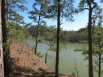
- On the north bluff, looking down-river

-

- West Spring Creek
-

- The trail follows the bed of an old logging railway near AR-298
There’s about 14 miles waiting for me. or a 2 day trip, out-and-back.


