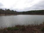
The Lake Sylvia Recreation Area features a man-made 18-acre lake for fishing, swimming, and non-motorized boating, plus camp sites with water & electric hookups, and a few miles of hiking trail. I first visited the area in September ’14 and was in the neighborhood again after finishing a weekend on the Ouachita Trail so I decided to take another look.
The trails are configured as 4 connected loops, with the longest – the 4-miler – using about 1.5 miles of the Ouachita Trail. I got GPS tracks of the trails and will add them to the next version of OT map 25. There is also a big parking lot that makes a nice trail head for the OT.
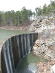
This is a pretty nice trail system for its size, passing through a variety of ecosystems. There is a spur to the top of Chinquapin Mountain and overlooks of the Narrow Creek Gorge below the dam, and the dam itself.
-
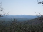
- Looking east toward the Pinnacle Mountains near Little Rock