
It was this stretch of trail where just 15 months ago I began my first section hike of the Ouachita Trail (completing it twice in 5 months!). This time I had a shuttle so it was just a one-way trip (eastbound). Much of the scenery was familiar, and even many of the pictures I took look similar to last time. One new thing was the side-trip to climb North Fork Pinnacle. As usual, I saw no other backpackers.
I guess this segment (section 8 plus the western 1/3 of section 9) could be summarized as: Sugar Creek, Flatside Wilderness (including the unnamed but scenic creek at mile 175, and Crystal Prong), Flatside Pinnacle, Brown Creek, North Fork Pinnacle, and Hillary Hollow. Maps 22-25.
The weather was okay, with clear skies, lows of 35 & 50 and highs around 70. More wildflowers are emerging, a couple trees that were probably Redbud were beginning to bloom, and some 4-legged reptiles were scurrying about.
-

- The first good view of Forked Pinnacle
-

- The unnamed creek at mile 175
-

- Flatside Pinnacle
-

- Forked Pinnacle, from the top of Flatside Pinnacle
-

- On top of North Fork Pinnacle, where the fire tower used to be
-
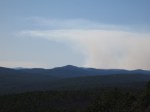
- Smoke, probably from a controlled burn
-

- The first Spring Beauty of the year
I hiked out Sunday AM with lots of time to spare so I went to Lake Sylvia to hike a few miles there – my first time back since Sep ’14.


