
This 31.6-mile trail, disconnected from the rest of the OHT west of Richland Creek, had been on the to-do list for a long time and is now checked-off – mostly – after a 4.5 day trip over the Thanksgiving weekend.
I say “mostly” because I skipped the western-most 3.5 miles this trip because I’ll be back in the area next weekend and will finish it then. The Ozark Highlands Trail Association is having a meeting at the Moccasin Springs trail head 12/3/16 @ 9:00 AM followed by a short hike of about 4 miles east from the Spring Creek trail head (and then a bushwhack up to shuttle cars on Rand Road).
I had heard this trail doesn’t have much water available and we were in the midst of a dry spell so I planned for the possibility of finding none. The trip was also done solo with no shuttle so it was all out-and-back, as usual. In fact, it was done as a series of 3 out-and-backs from each of Matney Knob, Brush Creek, and Moccasin Springs trail heads (about 56 miles total). It meant moving the car twice but gave me 4 opportunities during the hike to get water from the cache in the car and that proved important. An alternative if going one way is to cache water near the trail heads or in the woods near the 2 other crossings of highway 341.
Some of the scenery is stunning – well worth the trip – but those areas are often separated by several-mile-long boring walks on active forest roads on ridges high above the hollows where the water might be hiding. Maybe if the OHTA can get enough people mobilized in that area we can get some of that trail moved off the roads into more interesting and useful scenery.
The weather was decent, with highs around 60 and lows in the upper 30s. There was a heavy dew every night with fog in the morning and skies mostly overcast. Much of my gear got wet, or at least damp, and stayed that way.
I’m collecting GPS data for the trail and will prepare a map ASAP, and get the important data onto my trail info page.
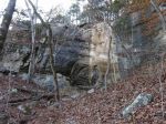
Some of my favorite parts: The rock garden near mile 22, the head of the Sneeds Creek drainage from about mile 18.25-19.25, the descent into and through the hollow at miles 14-15, the walk through part of Cap Fork Hollow from miles 9.75-10.75, the amazing bluff line around mile 4.25
-

- One of the many groves of old moss-covered cedars
-

- Overlooking the White River valley
-

- Matney Knob, I think, from about mile 21.5

-

- The Cripple Turkey trail head looked familiar
-

- Oh my, someone dropped their lucky deer’s foot!
-
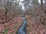
- One of the very few water sources

After the hike, I drove Rand Road along the southern edge of the Leatherwood Wilderness. It looks like there’s some pretty rugged and beautiful terrain in there. Another item on the to-do list!


Your site and maps are AWESOME!!
Thanks, comments like that are always welcome!