
I spent about 3 days in the Kanab Utah area, which has lots of stuff to see and do, and is kinda the gateway to Escalante, Bryce, Zion, and more. Kanab’s own Visitor Center and the BLM’s Grand Staircase/Escalante Visitor Center (on the east edge of town) have useful information. In addition, most restaurants and motels have racks of brochures.
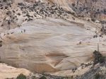
The Buckskin Gulch Trail runs about 16 miles SE through the Paria Canyon/Vermilion Cliffs Wilderness to Paria Canyon where you can continue about another 32 miles ESE to Lee’s Ferry on the Colorado River. See Trails Illustrated map # 859. The trail head is about 4.4 miles south of US89 off House Rock Valley Rd (about 40 miles east of Kanab). The road was in good shape – some roughness and some ruts but no deep sand.
I only hiked out 1.25 hours – about 2 miles? – so didn’t see the slot canyons that apparently draw some to this trail. There are generally braided paths on both sides of the creek bed with what seemed to be the most heavily used path going back-and-forth across the creek. This was my first experience hiking in loose sand and I found it pretty fatiguing. I was sometimes able to find firmer footing in the dry creek bed. The area is open to grazing and though I didn’t see any cattle there is ample evidence of them – I don’t think there was even a square inch of soil that hadn’t been disturbed. I can’t help thinking that is probably not beneficial.
This was my first close-up look at the canyon lands environment and it was great to see what nature can do to sandstone with a bit of wind, water, and time. On that topic, just a bit south of the Buckskin Gulch trail head is the Wire Pass trail head, which is apparently the shortest route to The Wave.


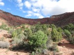
The Cottonwood Trail is located on the SW fringe of Kanab and runs about 5 miles SW on BLM land along the base of the Vermilion Cliffs to a dirt road leading into Cottonwood Canyon. The trail head is at the end of Stansfield Drive (37.0219, -112.5650). A topo map is available at the Grand Staircase/Escalante Visitor Center in Kanab, though it’s not needed. The Vermilion Cliffs are always in view so it would take some effort to get lost.
This trail meanders a lot, horizontally and vertically, through very dissected terrain with many layers of geology on display. In my case, it proved to be a good warm-up for later hikes. A highly recommended day hike.


Dinosaur Tracks is a short hike to the top of a ridge where dinosaur tracks are claimed to be found. The trail head is about 3 miles north of Kanab off US89 at a weigh station (37.0843, -112.5391). The distance is said to be about 1 mile round trip but it starts with a steep 350-400′ climb.
I’m not a paleontologist but I didn’t see anything that said to me “oh yeah, a dino footprint for sure”. I did see several impressions that appeared to be caused by erosion that a person could interpret as a track if they really wanted it to be one. The climb was invigorating and good conditioning for later hikes, and there were nice views from the top so it wasn’t a waste of time and I wouldn’t discourage anyone from seeing for themselves.

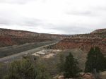
In the second picture my car is one of two near the lower left corner so you can see the vertical distance is not much less than the horizontal.
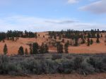
Coral Pink Sand Dunes State Park is about 11 miles west of Kanab and is apparently a popular place for sand-related recreation – whether riding over the dunes in an ATV or surfing down them on a snow board. It’s interesting to see but not my thing, I guess.


The Mansard Trail climbs to a rock shelter containing many petroglyphs. The trail head is about 5 miles east of Kanab at 37.03464, -112.42385, on the north edge of a subdivision. The hike begins with a short trek to the base of the Vermillion Cliffs before climbing 700′ to a plateau on top. From there it’s a mostly level 1 mile back to the site in Mansard Peak. A 3-mile round-trip featuring some scenic views in addition to the petroglyphs.
-

- The alcove

-

- View from the alcove
-

- View from the alcove
-

- View from the alcove
The Johnson Canyon driving tour runs about 16 miles on a paved road up this canyon. The Kanab Visitor Center has a flyer that details 17 attractions, which include geologic formations, pioneer graves, historic farms, scenic vies, and even the remains of a set where the Gunsmoke TV series was filmed. Most of the attractions are on private property but all are visible from the road. Johnson Canyon Road provides access to the western part of Escalante National Monument. The northern part of the tour has some good views of the White Cliffs, which expose the wonderfully-crossbedded Navajo Sandstone which lies above the Kayenta, Moenave, and Chinle formations seen in the Vermillion Cliffs.
-

- A bad angle on Eagle Gate Arch
-

- Not much left of this Dodge City
-

- Pioneer billboard
-

- White Cliffs
-
- Navajo Sandstone
Kanab is a great place to spend some time and there was still a lot I didn’t see. Maybe next time?


