I couldn’t go through the area without a trip to the Grand Canyon, could I? In fact, a week of backpacking from the north side of the canyon was the original reason for the whole trip but stuff happened so I found other things to see and do.
The canyon is grand, of course, but the drive from Kanab to the south side of the Grand Canyon via US 89A also had some good scenery and a few points of interest.
The road rose gradually from about 5000′ at Kanab to about 6000′ as I entered the Kaibab National Forest, then quickly gained another 2000′ of elevation while losing 20 degrees of temperature. The sage brush gave way to towering pine trees and the previous night’s rain in Kanab fell as snow here. On the east side of the Kaibab Plateau the road descended just as quickly back into the arid House Rock Valley. Summer to winter to summer in less than an hour.
Beyond House Rock Valley the road skirts the foot of the Vermilion Cliffs to Marble Canyon, where the Navajo Bridge crosses the Colorado River – well below the Glen Canyon Dam but still above the Grand Canyon.
South on US89 at Cameron I crossed the Little Colorado River, which has carved a pretty big canyon of its own. West on AR64 there are several places where a person can pull off the road to get a good look at the Little Colorado Gorge.
-

- Kaibab National Forest
-

- Vermilion Cliffs
-

- Navajo Bridge
-

- Colorado River
-

- Little Colorado River Gorge
The South Rim area is on the Coconino Plateau at around 7300′ elevation, well up from the arid lowlands and back in the Kaibab National Forest. The area is still rather dry but the pine trees are content.
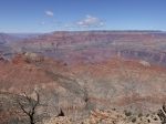
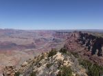
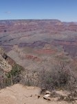
The Desert View area is the first place I came to after entering Grand Canyon National Park from the east. There is the Watchtower, gift shop, cafe, gas station, campground, and an overlook area on the rim where I got my first view of the canyon. I expected that it would be even more impressive in person than in pictures and I was right.
The Watchtower was built to look old. You can climb a narrow staircase to 3 upper levels with windows but cannot get out on the roof (and I doubt you’d have any better view from up there anyway). Note to self: get a camera that can take panoramic photos!
-

- Desert View Watchtower


I stayed in the campground 3 nights and it turned out fine. It was convenient and the host did a good job of suppressing the noisy people. The wind never stopped and I quickly got into the routine, when sitting at the picnic table, of ensuring that all books, maps, food packages, etc had something heavy on top of them or they would vanish. I also quickly learned to take everything out of my tent during the day and have only the essentials at night so it would not get covered/filled with the fine sand that easily blows though the mesh.
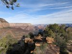
I spent the rest of the rest of the day driving west along the rim, stopping at all the overlooks (when parking was available) to Grand Canyon Village. GCV near the Visitor Center was utter chaos, bumper-to-bumper with people looking for a place to park and many simply leaving their cars on the side of the road even if it meant blocking a lane of traffic. It was the same situation near the hotels and train depot. I got the hell out and never looked back.
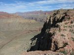
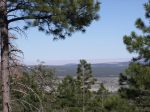
The Grandview Trail was my big hike for this visit. It descends about 2500′ over 3 miles from Grandview Point onto Horseshoe Mesa. From there, trails branch west down to Cottonwood Creek and east to Hance Creek with both branches leading to the Tonto Trail. I continued across the mesa, past the old miner shack and group campground (permit required), about 1.25 miles to the saddle on the mesa’s “thumb”. It took me about 2.25 hours to reach the miner’s shack and another 40 minutes to get here – my turnaround point.
The trail drops off the east side to another intersection with the Tonto Trail 1000′ below but there is a social trail that continues on the mesa – probably out to the point of the thumb (another .4 miles?).
-
- Looking down to Horseshoe Mesa

-

- Looking back up toward Grandview Point, I think
-

- Getting closer to the mesa
-

- M’kay!
-
- The miner shack
-

- Turnaround point – upstream
-

- Turnaround point – ahead
-
- Turnaround point – downstream
There was no ice or snow on the trail but patches of it were visible in some nearby shaded areas just below the rim. The upper 2/3 of the trail has had a heck of a lot of work put into it. There are many long steep stretches were rock has been stacked on edge like patio pavers to create a durable surface. The lower 1/3 is pretty natural – with some gullies and minor obstacles to climb over.
I got started at 6:45 AM and had a lot of shade on the way down but the trail was mostly in the sun on the way up and of course, it was warmer. I figured the hike out could take twice as long so I was looking at about 6 hours but somehow did it in 4. As a consequence, I was too stingy with my snacks and water. In hindsight, I should have used my altimeter to track my progress and ration my supplies.
Once out, I sat in the shade of a tree and engaged in some vigorous drinking and snacking, then got up and left my hiking poles behind. I didn’t notice their absence until the next morning. I went back to Grandview Point but naturally, the poles were gone – the first casualty of the trip.
While doing reconnaissance on day 1 I came across a road (FR 310) headed south from AR64 between Grandview and Moran Points. It goes a short distance before leaving the Park and entering the Kaibab NF. About a mile in is the Grandview Tower – an old fire tower, and a trail head for the Arizona Trail. You can still climb the tower. You can’t get into the “nest” at the top but there’s a good view from right below.

-
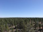
- The snow-covered San Francisco Peaks north of Flagstaff
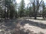
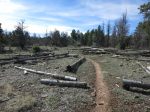
The Coconino Rim section runs southeast from this area so I thought it would be a great opportunity to get up-close and personal with a different sort of forest than I see at home. Much of it was a nice walk on fairly level terrain. Looking east one occasionally catches a glimpse of the Painted Desert in the far distance. The forest has a problem with Dwarf Mistletoe (seriously!) killing the Ponderosa Pines. I encountered several large areas that were barren due to either the mistletoe itself or the destruction of diseased trees. Some areas had been replanted. Apparently all mistletoe is parasitic and the stuff I see in Arkansas oak trees is probably going to kill them.

-
- Dwarf Mistletoe devastation
-

- A replanted area
-
- Painted Desert in far distance
I ran into a couple guys that were through-hiking the Arizona Trail. They were going south to north so were relatively close to the end and looking forward to dinner that evening at a pizza buffet in Tusayan and then taking a zero day before beginning their rim-to-rim traverse of the Grand Canyon and the sprint to the state line.
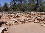
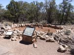
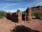
The Tusayan Ruins are the remains of a small Pueblo village dating back to about 1200 A.D. It’s hard to imagine what life must have been like for them, but I doubt they had much leisure time. I’d be seeing more Pueblo handiwork in the coming days.