
Officially open to mountain bikers and hikers, the Wildcat Mountain trails are a nice place to spend a day or even a weekend in the Ouachitas. Situated west of AR9 and a couple miles south of Lake Sylvia, the trail is mostly on old logging roads which are visible on USGS topo maps. My aim was to explore the outer perimeter as shown on the USFS map and then see what else I could find.
I hiked the loop counter-clockwise and for the most part found it as portrayed in the USFS map. In the southeast area there was extensive blowdown that I spent some time trying to work through before deciding the effort and risk was just too high. I back-tracked and took a road detour that got me to the west end of Y35M (on the USFS map) then headed north, back on the trail.
Further north I ran into a smaller area of blowdown. I was able to work through it but someone riding or carrying a bike certainly wouldn’t. I think these two blow down areas and all the other trees down on the south loop probably render it useless as a bike trail.
After lunch on Bobcat Point I took a detour to the unnamed 1367-foot peak northwest of there. USGS maps showed an old road that went close to the peak but the road hadn’t been used in a long time and was overgrown with small pine trees and vines. Still, that turned out to be easier than getting off the road. This small rocky point was a heck of a lot of work to get to but it did have some nice views: an even taller unnamed peak to the north, Wildcat Mountain to the east, nice scenery to the south, and North Fork Pinnacle to the west. I think I could also see the tip of Flatside Pinnacle to the west.
-

- Looking west: North Fork Pinnacle in the center with the tip of Flatside Pinnacle a bit to the left.
-
- Looking southwest
-

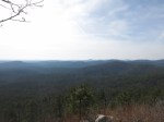
- Looking southeast
-

- Looking east at Wildcat Mountain
I traveled at least one old road that is obviously being used as a trail but isn’t on the USFS map and passed several others by. I did have my new GPS receiver and have the track along with many junctions marked for future exploration. As soon as I work out the details of map preparation I’ll add a link on my Ouachita Mountains Trails page.
The USGS topo maps show many other old roads in the area and it might be interesting to explore those and map out the ones that are still hikeable to see if I can link them in an even bigger loop.
Update: I’ve produced a trail map with the GPS data I have from this trip. I’ll update this map as I get more data from future exploration.


