
Located in the Buffalo National River, the 2.2-mile Cecil Creek Trail (CCT) and the adjoining 3-mile Cecil Cove Bluff Trail (CCBT) form (with a 1.5-mile road walk) the Cecil Cove Loop. The trail head is in the historic community of Erbie – between Compton and Marble Falls. I and three others (TC, CC, and CE) set out for a little President’s Day trip exploring the creek, nearby waterfalls, and historic sites. The area is well-described in Tim Ernst’s Buffalo River Hiking Trails and here is a map of the area that is 1:24000 scale if printed on 8.5×11″ paper.
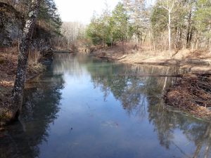
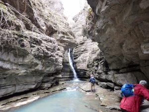
The CCT begins heading downhill right away, leveling off at a pond where beavers have dammed the outflow of Van Dyke Spring. We hiked in a bit more than a mile, following Cecil Creek upstream on the level, and found a nice place to set up a base camp. Afterward we still had enough daylight left to make the 1/2-mile trip along a nice side-creek to 71′ Thunder Canyon Falls. The route gets pretty treacherous as it nears the head of the box canyon, with lots of very slick rock – as if it were covered with ice. The rocks are so contorted it’s not possible to get a picture of the whole waterfall.
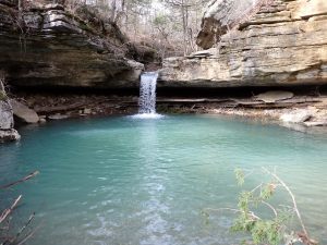
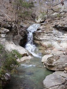
The next morning we made our way further up Cecil Creek, leaving the trail at the CCT/CCBT junction near Mud Cave to continue upstream, then up a tributary to Broadwater Hollow Falls (21′) and less than 100 yards farther to Paige Falls (8′). On the way out we passed Devil’s Den – a rather deep sinkhole.
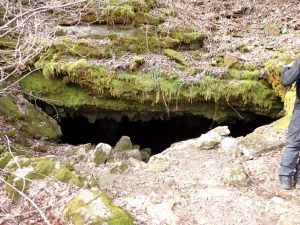
We then headed back to the CCT/CCBT junction and up the hill on the CCBT with a side trip to Mud Cave. About 1/2-mile up, as the trail leveled off, was the Jones Cemetery and then the Jones Homestead about .2 miles farther. I think the newest graves were from the 1930’s with one from 2020. All that is left of the homestead is part of the chimney and some foundation stones.
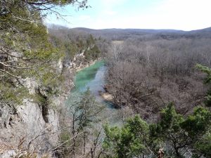
Monday morning we hiked back to the trail head, dropped our packs and dashed down to Goat Bluff for a look at the Buffalo River from on high.


I hiked the loop in the fall of 2012 but was surprised at how unfamiliar the area was this time. The weather was pretty nice and we encountered several groups of dayhikers but we seemed to be the only campers out there.
There was a landslide on the CCBT a couple years ago and the ground in that area somewhere south of the Jones Homestead is reported to still be pretty unstable so be alert if you’re planning to hike through there. NPS has done a lot of work to fix erosion issues on the Compton-Erbie road and it was mostly good within the BNR boundary. There were a couple places where recent rains had carved ditches across the road and one place where half the road was sliding down the hill.


