
The weather was beautiful Friday – perfect for hiking – so naturally it was one of the rare Fridays that I needed to work. The forecast for Saturday and Sunday had a good chance of thunderstorms pretty much all day but I said I was going to finish this trail ASAP no matter what it took, so Friday evening I headed southwest.
The goal was to hike from the campground at mile 23.7 to Deadman Gap at mile 8, leaving a mere 8 miles (times 2) for the final trip. This segment goes along the north side of Winding Stair Mountain, beginning and ending at the ridge but in some areas dipping 800-900 feet below, so there are some climbs (as usual). Level places where one can camp are rare, but there are 2 relatively new shelters (at miles 9.1 and 16.2) that can help. I did this segment as two day-hikes so I could carry a lighter pack with more water, though water was actually plentiful on this usually-dry segment due to the recent rains. Lots of little waterfalls to see and a really nice spot where the trail crosses the upper reaches of Cedar Creek and the water crashes down a very steep and rocky slope. There are several areas with good views over the Holson Valley.
I camped at the Winding Stair Backpacker’s Campground Friday and Saturday nights and had the place to myself. This is a walk-in tent camping area about 100 yards west of the main Winding Stair Campground. There are 6 pad sites, two picnic tables, several fire rings, a grill, and vault toilet, but no water (and none at the other campground). A problem with the pad sites is that they’re slightly concave as a consequence of years of use, and they drain very poorly. Saturday morning’s thunderstorm dumped some rain quickly, and the floor of the old tent I was using is no longer 100% waterproof so I soon found myself in a puddle with a lot of wet gear. Another mishap was a mouse visiting me several times both nights and tearing a 3″x9″ piece of mesh from the tent.
After the early thunderstorm Saturday, a light rain settled-in. I hiked from the campground west to mile 16 and back. I expected the distance to be about 8 miles each way but it was actually a mile short (due to old trail reroutes) so I was back at the campground by 3:30 PM, leaving a lot of the day unused. I wished I had continued hiking at least to mile 15 but I didn’t know when I turned around at 16 that 30 minutes later the sun would come out and the rest of the day would be great. Hindsight… I spent the rest of the day moving my tent to a patch of properly-draining forest floor and getting stuff dried out, then had a couple hours to read.
Another storm came through Sunday morning but the skies cleared shortly after dawn. The forecast said a 60% chance of severe storms in the afternoon so I resigned myself to an unpleasant afternoon and headed out. I packed and drove to Deadman Gap, parking at the overlook area and then walking down the road to where the trail crossed. The plan was to hike from there – mile 8 – east to mile 16 and back. I hiked the area between 8 and 8.7 about 3 years ago during my very first visit to the Ouachitas so it was interesting to see that again. It was familiar but with much more vegetation now.
The mileage on this leg was pretty accurate but it seemed much longer. This area has many rock gardens and boulder fields where you really have to be careful, a couple big ups and downs, and lots of small ups and downs that add up big. It took about 10.5 hours so it’s one of my longest hikes ever time-wise. The rain held off until I was about 20 minutes from the end and consisted of a 2-minute shower and 5 minutes of light rain so I was real damn fortunate. Once I got back up on top of the mountain I could see some serious storms in the valleys below on both sides but on top there was no more rain.
-

- Looking west along the ridge of Winding Stair Mountain. A bit of the highway is visible in the center.
-
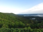
- Sunday AM: a bit of fog in the Holson Valley


-

- This was right in the middle of the trail – no searching required.
-
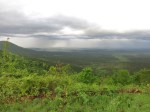
- Sunday PM: storms in the Holson valley to the north
-

- Sunday PM: storms in the Kiamichi valley to the south
So, 8 miles to go?! Technically, I have now hiked all of the Ouachita Trail because I did miles 0 to 8 during that first visit 3 years ago. The big deal, though, is to do that stretch again. Soon. The temperatures are getting uncomfortably warm for hiking, the briars and poison ivy are taking over the trails, and all the biting insects are out in force so I think the end of this (local) hiking season is near.


