
I planned one stop on the way back from Virginia but added two more. The first was New River Gorge National River – a 72,000 acre national park that encompasses 53 miles of the New River. The area is chock-full of hiking, camping, floating, fishing, and other recreational opportunities as well as driving tours if you don’t feel like doing anything. Nearby is the Gauley River, which is a popular destination for whitewater enthusiasts.
Along much of its length, the New River is in a rather deep gorge and near the north end US-19 crosses on an often-photographed bridge that is 876′ above the river. Completed in 1977, it’s the 2nd highest bridge in the US and the world’s longest single-arch steel span. In addition to photographers, the bridge is also very popular with BASE jumpers, especially on Bridge Day.
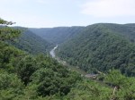
Next to the bridge is the Canyon Rim Visitor Center, which has a deck out back where one can see the river, the bridge, and a couple miles of the gorge upstream. There is also a walkway that leads down to a couple platforms where you can get even better views and a bit of exercise climbing the 178 steps back out. It was along this walkway that I spotted many rhododendrons blooming – I came far enough north that they were back “in season”.
Visible in the gorge picture below is the Fayette Station Bridge, completed in 1889, and the only way for cars in this area to cross the river for many years. The bridge is still open and is part of the Fayette Station Road Tour – a narrow, winding, and mostly one-way (westbound) road that descends for about 3 miles into the gorge, crosses the bridge, and then climbs for about 3 miles back out. This road passes a public access area for the river and at least one trail head. I walked across the old bridge to get pictures of the new bridge.
Driving over the new bridge was anti-climactic. There is no view (unless you’re sitting in a semi truck?) and no sensation of even being on a bridge so don’t feel bad if you take the “low road” (westbound only) and decide to skip the new bridge.
I got Trails Illustrated map #242 and a book for other WV hiking trails at the visitor center and will plan to spend more time there the next time I’m in that area. I might even do one of the many float trips offered.


I have a work trip planned to WV in November, thanks for the tip on a side-trip!
By all means, get there if you can. There’s apparently 80+ miles of hiking trails if you’ve got time for that.