
I thought last year’s trip to Wyoming’s Wind River Range was probably a once-in-a-lifetime thing but two of the participants wanted to go back this summer so RC, TC, and I did just that.
This year’s trip was mostly on the west side of the range and a bit further north than last year, mostly in the Bridger Wilderness but partially in the Popo Agie Wilderness. The trip outline: from the Big Sandy Opening trail head go north past Dad’s, Marm’s, Skull, and Mae’s Lakes, then northeast over Hailey Pass and around Grave Lake, south to Washakie Lake, west over Washakie Pass (the high point at 11600′) and toward Skull Lake, then retrace our path south to the trail head. This is described as the Baptiste Lake Loop in Backpacking Wyoming. Part of this lollipop is on the Continental Divide Trail so I’ve knocked off a few more miles of that.
We had great weather, no camp fires due to a burn ban, and a new moon. That all added up to excellent star gazing conditions. I spotted 3 of the 4 constellations I can identify!
We spent our final hours of captivity in Pinedale WY, with a tour of the Museum of the Mountain Men, a drive up Skyline Drive above nearby Fremont Lake, dinner at Wind River Brewing Co, a comfy bed at the historic Log Cabin Motel, then breakfast at the Wrangler Cafe.
-

- Lake Fremont
-

- Pronghorn mugging for the camera
-

- A vista near the end of Skyline Drive
-

- Log Cabin Motel
The drive to the trail head is a rather long one with the final hour+ on gravel roads that are probably passable with a typical passenger car. The Big Sandy trail head is one of the most popular, being the usual starting point for trips to the famed Cirque of the Towers, so we weren’t surprised by the number of cars there. We made it to Dad’s Lake and found a secluded camp site near the north end for night 1. As night fell, some mule deer made their way along the edge of our camp and down to the lake.
-
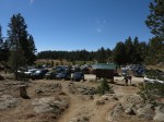
- Part of the trail head parking
-
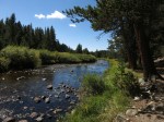
- Big Sandy Creek
-

- Fish Creek Park
-
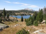
- Approaching Dad’s Lake
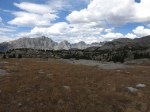
On day 2 we continued north past Marm’s Lake, Washakie Creek, and Skull Lake to stop for the night at Mae’s Lake, with Pyramid Peak towering over us to the north. We had a brief light rain as we set up camp and a bit of frost in the morning.
-
- Marm’s Lake
-

- Skull Lake, with Pyramid Peak looming
-
- Mae’s Lake, at the south base of Pyramid Peak
-

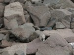
- My first stoat sighting – Mustela erminea
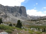
Day 3 would be one of the big ones, starting with the climb to Twin Lakes and through 11150′ Hailey Pass (the continental divide), then descending steeply to the valley at the head of Grave Lake, climbing again across the base of Pilot Knob, then finally descending to Grave Lake. Along the way were views of Mt Hooker, whose 1600′ face is a favorite with rock climbers. Just a short distance north of Grave Lake is the border with the Wind River Reservation.
-
- The morning sun warms Mount Geikie and Ambush Peak west of Mae’s Lake
-
- Mount Geikie and Ambush Peak, west of Mae’s Lake
-

- Looking back at Mae’s Lake
-

- Pyramid Peak from the upper of the Twin Lakes
-
- Looking ahead (north) to Hailey Pass
-
- Looking back (south) from Hailey Pass
-
- Looking north from Hailey Pass
-
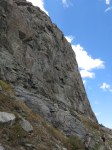
- Mt Hooker
-

- The falls at the head of Grave Lake
-

- Grave Lake
-
- Hiking along the base of Pilot Knob
-

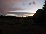
- The sun sets behind Pilot Knob and Mt Hooker
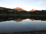
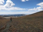
Day 4 basically begins the hike back home and is a relatively easy one, following the South Fork of Little Wind River for a ways before turning uphill toward Washakie Lake. We camped at the base of a peninsula that almost divides the lake and hiked out to the end of the peninsula after dinner.
-

- Sunrise on Mt Hooker and Pilot Knob
-
- The beach at Grave Lake
-
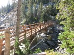
- The bridge at the outlet of Grave Lake
-

- Hiking along the South Fork of Little Wind River toward Buffalo Head
-

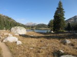
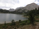
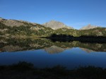
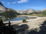
- Lake Washakie, from the base of the peninsula
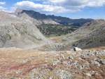
Day 5 started with some rather dramatic skies and scattered rain visible on three sides of us. The skies cleared and clouded-over again a couple times while we ate breakfast, before finally clearing for good. This was going to be another big day, starting right off with a climb through Washakie Pass, back across the continental divide, then dropping to intersect the trail we hiked-in on just south of Skull Lake. From there it was back past Washakie Creek and Marm’s Lake to stop at Dad’s Lake and camp in the same spot again. We had a brief rain shower in the late afternoon and more overnight.
-
- Buffalo Head
-

- Mt Washakie
-

- Buffalo Head
-

- A look back at Washakie Lake
-

- Washakie Pass with Macon lake on the right
-

- Looking back at Macon & Washakie Lakes from near the top of the pass
-
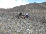
- Taking shelter for a snack and rest stop in the pass
-
- Pika
-
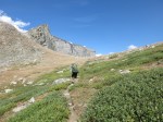
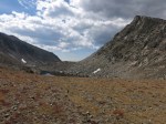
- Looking ahead (SW) from Washakie Pass
-
- Mount Geikie, Ambush and Raid Peaks come back into view
-

- A glimpse of the famed and far-off Cirque of the Towers
Day 6 was about a 3-hour hike out – mostly downhill – and then a detour back to Pinedale for a lunch feast at Old Stones Smokehouse and Country Pizza before beginning the long drive home. A frequent topic of conversation was what part of the Winds to visit next year.


